A heat wave is a period of abnormally and uncomfortably hot and usually humid weather.
The World Meteorological Organization is specific in its definition by stating that a heat wave is when the daily maximum temperature for more than five consecutive days exceeds the average maximum temperature by 9 degrees.
The National Oceanic and Atmospheric Administration, or NOAA, has analyzed the number of heat waves in the United State by decade, from 1961 to 2019, for 50 large metropolitan areas. Their analysis shows a steady increase in the average number of heat waves per year, with about two in the 1960s and six per year in the 2010s (2010-2019).
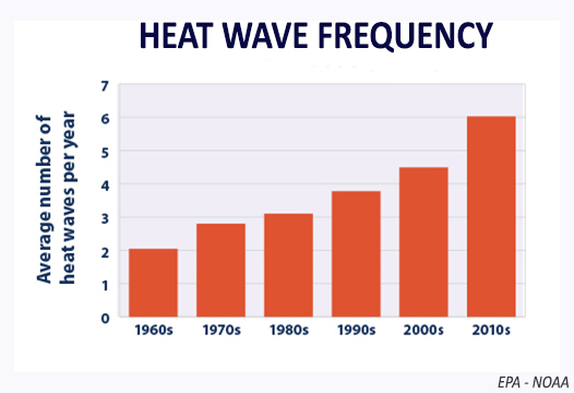
Of the 50 metropolitan areas studied, 46 experienced a statistically significant increase in heat wave frequency. The heat wave duration, defined as the length of each individual heat wave in days, has also been increasing — from an average length of three days per year in the 1960s to four days in the 2010s decade.
Heat waves are caused by very hot, stagnant air masses. Regions that suffer under intense hot spells are usually dominated by a surface high-pressure system with a mid-tropospheric ridge aloft. Dew points are also high, and to compound matters, wind speeds are often low. Clear or partly cloudy skies allow intense solar energy to further heat the ground and the air mass.
Heat waves are just one of the types of extreme weather becoming more frequent because of human caused climate change. So, it is a good time to consider the dangers of hot weather, as extreme heat kills more people in the U.S. than any other type of weather event. Each summer in the United States, approximately 175 to 200 deaths are attributable to heat waves. Most of these deaths occur in cities, particularly northern cities.
Steve Ackerman and Jonathan Martin, professors in the UW-Madison department of atmospheric and oceanic sciences, are guests on WHA radio (970 AM) at 11:45 a.m. the last Monday of each month. Send them your questions at stevea@ssec.wisc.edu or jemarti1@wisc.edu.