Why did two meteorologists receive the Nobel Prize?

Princeton University professor Syukuro (Suki) Manabe is generally considered the father of climate modelling, a sentiment echoed by the Royal Swedish Academy of Sciences, which said he “laid the foundation for the development of current climate models.” (Photo credit: Denise Applewhite, Princeton University)

It was with great excitement that we learned last week that the Nobel Prize in Physics was shared among three scientists who had each made “groundbreaking contributions to our understanding of complex systems.” Two of the three so awarded were meteorologists, professor Syukuro (Suki) Manabe of Princeton University and professor Klaus Hasselmann of the Max Planck Institute for Meteorology.

Together, they were cited for their work in “the physical modeling of Earth’s climate, quantifying variability and reliably predicting global warming.”

Manabe led pioneering work in the 1960s that demonstrated, through numerical modeling, how increases in the carbon dioxide fraction in the atmosphere results in a global temperature rise. Though his original model was simple compared to the sophisticated tools available today, his sense of what is influential and what is not allowed that model to make remarkably accurate predictions of conditions 50 years later.

Klaus Hasselmann (Photo credit: Max Planck Institute for Meteorology)

He is generally considered the father of climate modelling, a sentiment echoed by the Royal Swedish Academy of Sciences, which proclaimed that he “laid the foundation for the development of current climate models.”

Hasselmann’s work in the 1970s produced the first numerical model that adequately linked climate and weather processes together, thus carrying Manabe’s pioneering work into an even more physically accurate realm.

Together, these giants have set a course for our science in which important advances require simultaneous consideration of climate science and weather systems science.

Awarding the Nobel in Physics for such work is, as Thors-Hans Hansson, chair of the Nobel committee said, a clear indication that “the modelling of climate is solidly based in physical theory.”

Steve Ackerman and Jonathan Martin, professors in the UW-Madison department of atmospheric and oceanic sciences, are guests on WHA radio (970 AM) at 11:45 a.m. the last Monday of each month. Send them your questions at stevea@ssec.wisc.edu or jemarti1@wisc.edu.

Category: Climate, Meteorology

Comments Off on Why did two meteorologists receive the Nobel Prize?

What impact did Sputnik have on weather monitoring and predictions?

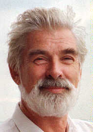
Sputnik, the first artificial satellite, was launched into space on October 4, 1957, by the Union of Soviet Socialist Republics (USSR). This event pressed the United States to move forward with its satellite program. (Image credit: NASA)

Sixty-four years ago the Soviet Union launched Sputnik, the first artificial satellite. This was not welcome news in the United States as it confirmed that the Soviets were well ahead of us in the development of rocket technology. In fact, this launch greatly accelerated the “space race” that eventually culminated in the U.S. moon landing in July 1969.

The ancillary benefits of that decade of rapid development are still with us today. Much of the remarkable advances in computer technology were made during the space race, as were many component technologies that currently power popular devices such as cell phones and digital music devices.

Quite separate from those advances, the advantage of having satellites in space for the purposes of improving understanding of our atmosphere, monitoring its climate and predicting its weather cannot be overstated. The applications of satellite technology to weather prediction have blosso0med in the last 40 or so years.

Since about 70% of the earth’s surface is covered by oceans, observations of the atmosphere over such areas by conventional observing systems is nearly impossible. Satellites provide an enormous amount of observational data from these regions that is fed into the ceaseless forecast operations around the world.

Satellite observations of tropical weather systems has been extremely important in the rapid increase in hurricane forecast accuracy that as occurred over the past few decades.

Finally, a good number of the scientists currently working on atmospheric problems were attracted to science generally as a result of the Apollo program in the 1960s. Thus, the anniversary today is a particularly compelling example of the power of answering a national call to action in the face of looming threat. Perhaps we can muster the same fortitude as we stare down the climate problem.

Steve Ackerman and Jonathan Martin, professors in the UW-Madison department of atmospheric and oceanic sciences, are guests on WHA radio (970 AM) at 11:45 a.m. the last Monday of each month. Send them your questions at stevea@ssec.wisc.edu or jemarti1@wisc.edu.

Category: Climate, History

Comments Off on What impact did Sputnik have on weather monitoring and predictions?

What is the ozone hole?

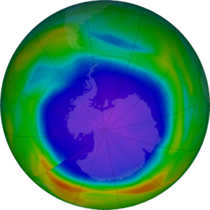
Total ozone over the Antarctic on September 25, 2021. The purple and blue colors identify the ozone hole (where there is the least ozone) and yellows and reds indicate the most ozone. (Image credit: Ozone Hole Watch, NASA Goddard)

Ozone is a colorless gas made up of three oxygen atoms (chemically denoted as O3). It occurs naturally in small amounts in the upper atmosphere (the stratosphere), about 18 miles above the surface.

Ozone in the stratosphere is a result of a balance between sunlight that creates ozone and chemical reactions that destroy it. Ozone is created when oxygen (O2), is split apart by ultraviolet energy emitted by the sun into single oxygen atoms. The single oxygen atoms can rejoin to make O2, or they can join with O2 molecules to make ozone.

The winter atmosphere above Antarctica is very cold. These extremely cold temperatures are a good environment for forming polar stratospheric clouds, or PSC. PSCs begin to form during June, which is wintertime at the South Pole. Chemicals on the surface of the particles composing PSCs result in chemical reactions that remove atmospheric chlorine.

When the Sun returns to the Antarctic stratosphere in the spring (our fall), sunlight splits the chlorine molecules into highly reactive chlorine atoms that rapidly deplete ozone. The depletion is so rapid that it has been termed a “hole in the ozone layer.”

The amount of ozone in the atmosphere is routinely measured from satellites. The ozone hole appears high over the continent of Antarctica as very low values of ozone in the stratosphere. Typically, the Antarctic ozone hole has its largest area in early September and lowest values in late September to early October. This year’s hole is shaping up to be larger than average in area, but well within expectations.

Sept. 16 is the International Day for the Preservation of the Ozone Layer. That day celebrates the 1987 anniversary of the Montreal Protocol on Substances that Deplete the Ozone Layer. The Montreal Protocol led to a ban on a group of chemicals called halocarbons that were blamed for exacerbating the annual ozone hole.

While the ozone layer is beginning to recover, it is likely to take until the 2060s for the ozone-depleting substances used in refrigerants and spray cans to completely disappear from the atmosphere.

Steve Ackerman and Jonathan Martin, professors in the UW-Madison department of atmospheric and oceanic sciences, are guests on WHA radio (970 AM) at 11:45 a.m. the last Monday of each month. Send them your questions at stevea@ssec.wisc.edu or jemarti1@wisc.edu.
Category: Climate, Meteorology, Phenomena

Comments Off on What is the ozone hole?

When does autumn begin?

The changes are subtle but apparent to the keen observer at this time of year — the first changes of color on trees, the earlier sunset and the rapid temperature drop that follows.

Summer is ending and fall is taking its place. This fact is formalized at 2:20 p.m. Wednesday when the autumnal equinox occurs.

This is, of course, the time when the Earth enjoys equal amounts of day and night for the first time in six months. Every day after Wednesday here in the Northern Hemisphere will have a longer night than day with the difference reaching its maximum just before Christmas on the day of the winter solstice at 10:59 a.m. on Dec. 21.

In fact, at the North Pole, the sun will set on Tuesday night and not rise again until late March. The extinction of daylight at the North Pole and its shortening everywhere else in the hemisphere has consequences that are inescapable — the air gets colder with each passing day at high latitude and then begins to creep slowly southward throughout the fall.

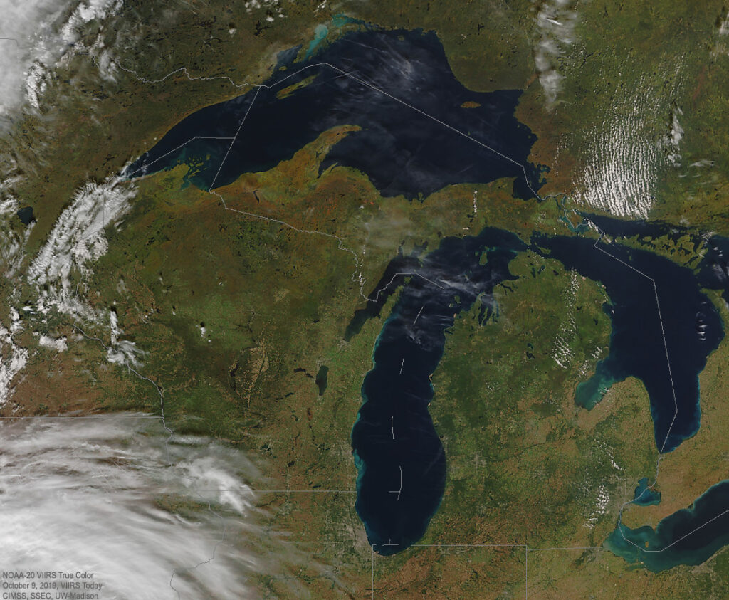
Autumn 2019 from space! Credit:CIMSS

Here in Wisconsin, we are less and less susceptible to the invasion of warm and humid tropical air masses. With less water vapor in the air, even pleasant sunny days are crisper and nighttime cooling occurs more rapidly after sunset because water vapor is a potent greenhouse gas. The fraction of our precipitation that comes from more energetic and well-organized storms will also increase, taking over from summertime’s thunderstorms.

It is a beautiful and exciting time of year, and the cosmological stage is officially set on Wednesday.

Steve Ackerman and Jonathan Martin, professors in the UW-Madison department of atmospheric and oceanic sciences, are guests on WHA radio (970 AM) at 11:45 a.m. the last Monday of each month. Send them your questions at stevea@ssec.wisc.edu or jemarti1@wisc.edu.
Category: Climate, Meteorology, Seasons

Comments Off on When does autumn begin?

Why do tornadoes happen in hurricanes?

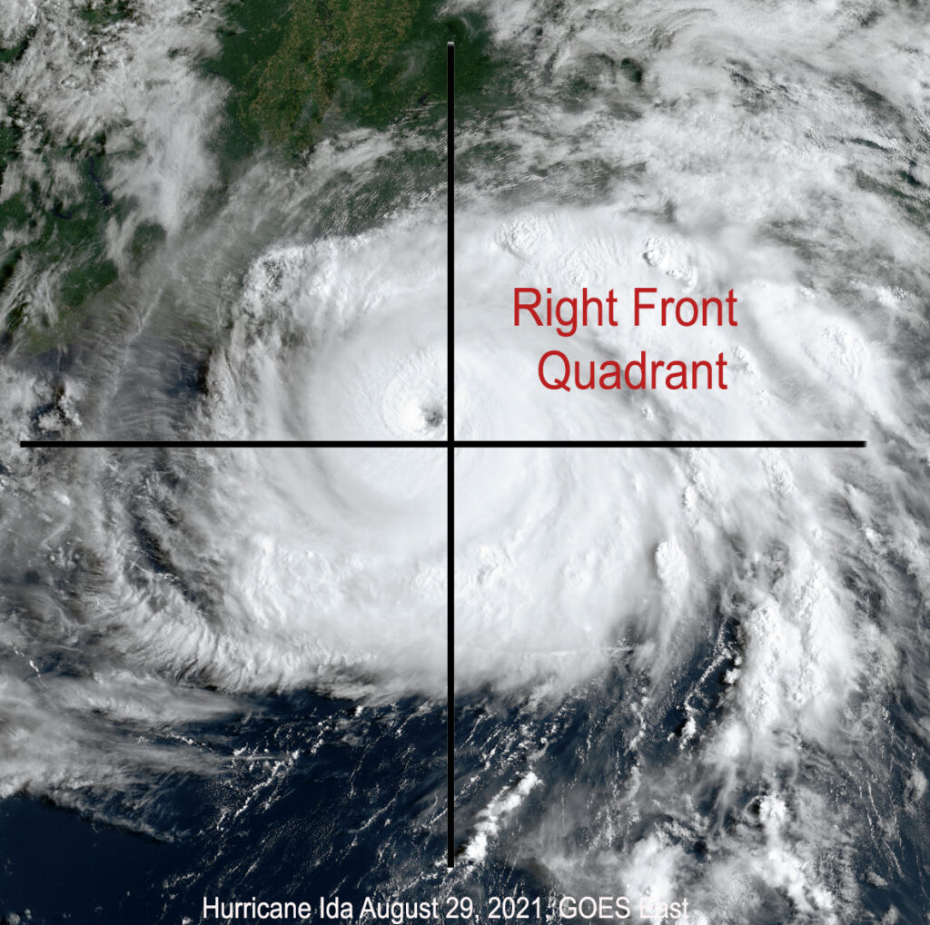
Tornadoes spawned by hurricanes typically occur in the right front quadrant where wind shear differences due to friction from land is greatest.

When hurricanes make landfall, they can spawn tornadoes.

The friction over land is much stronger than friction over water, where the hurricanes form. Frictional force quickly weakens the farther you get from the ground.

When a hurricane makes landfall, the winds near the ground slow down, while the upper-level winds keep their momentum. This change in the wind speed — and sometimes direction — with height is called a “wind shear.” This can lead to a column of air rotating that can generate a weak tornado.

The tornadoes spawned by hurricanes typically occur in the right front quadrant of the storm and usually within 12 hours after landfall. The tornadoes are very often embedded in rain bands. Unfortunately, meteorologists cannot accurately predict if a hurricane will produce tornadoes.

On average, Florida had 60 tornadoes a year during the period 1989 to 2019. They are mostly associated with hurricanes. Compare this to Wisconsin, which averages 24; Minnesota, averaging 40; and Michigan, which averages 15 tornadoes a year.

The tornado’s strength is determined by the damage the tornado does, which is an estimate of the wind speed of its rotating winds. All tornadoes are assigned a single number from the Enhanced Fujita scale according to the most intense damage caused by the storm.

This scale is based on the research of professor Ted Fujita and uses a set of 28 indicators, such as damage to barns, schools and trees. The degree of damage is used to determine the EF scale of every tornado. The weakest tornado is EF0, with wind speeds of 65-85 mph that will peel the surface off some roofs, cause some damage to gutters or siding and break off tree branches.

Hurricanes by themselves cause natural disasters, so even weak tornadoes are a problem.

Steve Ackerman and Jonathan Martin, professors in the UW-Madison Department of Atmospheric and Oceanic sciences, are guests on WHA radio (970 AM) at 11:45 a.m. the last Monday of each month.

Category: Meteorology, Phenomena, Severe Weather, Tropical

Comments Off on Why do tornadoes happen in hurricanes?