What is the spring equinox?

The spring equinox marks the beginning of the spring season in the Northern Hemisphere. Also called the vernal equinox, it is the time of year when the sun rises due east and sets due west, no matter where you live. Earth’s axis of spin is tilted at an angle of 23.5 degrees from its orbital plane and always points to the North Star. The orientation of Earth’s axis with respect to the sun changes throughout the year and is the fundamental cause of our seasons.

On the equinoxes, the axis is not pointed at or away from the sun. This results in all areas on Earth experiencing 12 hours of direct sunlight. On the equinox and at the equator, the sun appears directly overhead at noon.

Satellite view of Earth on March 20th 2023, Spring Equinox in the Northern Hemisphere.

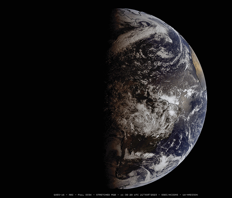
The equinoxes occur when the sun’s rays strike the equator at noon at an angle of 90 degrees. During the spring and fall equinoxes, the sun is above the horizon for all locations on Earth for 12 hours. During the vernal equinox, the sun is moving from south to north as it crosses above the equator.

For a long time, people have marked the changing of seasons and the sun’s track across our skies. Stonehenge was constructed in a way that marks its relation to the Sun’s position in the sky and in different seasons. At Machu Picchu, stones mark the four cardinal directions so that exactly at noon on the equinox, no shadow is cast. In Chaco Canyon, the ancestral Puebloan people carved spiral designs into rock that track the seasons.

The sun crosses the equator today at 4:24 p.m. Central Daylight Time, a good time to go outside and celebrate the event.

Steve Ackerman and Jonathan Martin, professors in the UW-Madison department of atmospheric and oceanic sciences, are guests on WHA radio (970 AM) at 11:45 a.m. the last Monday of each month. Send them your questions at stevea@ssec.wisc.edu or jemarti1@wisc.edu.

Category: Meteorology, Seasons

Comments Off on What is the spring equinox?

How are storm warnings defined?

Weather watches and warnings are issued by the National Weather Service under specific weather conditions.

A watch means that you should be aware that a weather hazard may develop in your area. A warning message is when the hazard is developing in your area.

When a warning occurs, you should take immediate action as suggested by the NWS. Warnings are based on observations of hazardous weather and are thus often issued for smaller areas. An advisory is a less urgent statement issued to raise awareness of a coming weather event that may cause some inconvenience.

As for winter storms, the NWS defines the following:

  • Winter storm watch: A watch means that severe winter conditions, such as heavy snow or ice, may affect your area, but where, when and how much snow are still uncertain. A watch is intended to provide enough lead time for you to prepare and thus is issued 12 to 36 hours before the predicted event.
  • Winter storm warning: The NWS issues a warning when there is a forecast of a significant winter weather event including snow, ice, sleet, or blowing snow, or a combination of these hazards that exceed locally defined criteria.
  • Winter weather advisories inform you that winter weather conditions are expected to cause significant inconveniences that may be hazardous. If caution is exercised, advisory situations should not become life-threatening.
  • Blizzard warnings: These let you know that snow and strong winds will combine to produce a blinding snow (near zero visibility), deep drifts and life-threatening wind chill.
Weather Guy Steve Ackerman (3rd from right) attended the UW-Madison StormReady ceremony in 2015. UW Chancellor Becky Blank is holding the StormReady sign with NWS Director Louis Uccellini. The designation of the University was a collaborative effort by UW Emergency Management, Campus Police, CIMSS, SSEC, AOS, and the NWS.

Steve Ackerman and Jonathan Martin, professors in the UW-Madison department of atmospheric and oceanic sciences, are guests on WHA radio (970 AM) at 11:45 a.m. the last Monday of each month. Send them your questions at stevea@ssec.wisc.edu or jemarti1@wisc.edu.

Category: Severe Weather, Weather Dangers

Comments Off on How are storm warnings defined?

How did this year’s winter rank?

Meteorological winter in the Northern Hemisphere is often defined as the three months of December, January and February. The just-ended winter of 2022-23 was notable in a number of ways.

First, here in Madison we started with a chilly month of December during which we averaged 0.8 degrees below normal. This was also the only month of the season in which we had a day with a high temperature below zero — minus 3 on Dec. 23.

January was 7.6 degrees above normal and was followed by a February that was 4.4 degrees above normal. Thus, overall, December, January and February were 3.71 degrees above normal in Madison this winter.

Winter climate statistics for Madison, Wisconsin. Credit: NWS

On the hemispheric scale, we can measure the areal extent of air colder than minus 5 degrees Celsius — 23 degrees Fahrenheit — at about 1 mile above sea-level (formally, at a level where the atmospheric pressure is 850 millibars) with records back to 1948-49. This year turned out to have the 16th smallest average areal extent over December, January and February — thus, by this measure, it was the 16th warmest winter in the last 75 years.

In fact, of the top 20 warmest winters measured this way, 17 have come since 2000-01. This is not a weird coincidence but instead is part of a longer trend that unequivocally reveals a slow but systematic warming of the planet. It is well past time that we as a society stop arguing about what is now settled fact — that global warming is real and ongoing — and start spending our collective intellectual energy on deciding how best to confront this reality.

Trends in average surface temperature from 1993-2022. Overall, land areas warmed faster than oceans. The most extreme warming (darkest red) was in the northern hemisphere. Data from NOAA NCEI.

Steve Ackerman and Jonathan Martin, professors in the UW-Madison department of atmospheric and oceanic sciences, are guests on WHA radio (970 AM) at 11:45 a.m. the last Monday of each month. Send them your questions at stevea@ssec.wisc.edu or jemarti1@wisc.edu.

Category: Climate, Meteorology, Seasons

Comments Off on How did this year’s winter rank?

How much energy goes into making snow?

Since Dec. 1, Madison and Dane County have received approximately 40 inches of snow — 3 inches above normal for that span.

Snow is a form of solid water, and water is the only substance that occurs naturally in all three phases — solid, liquid and invisible gas — in the Earth’s atmosphere.

Snowflake (Photo credit: Wilson Bentley Snowflake Collection)

Of course, that means that the 40 inches of snow began as the equivalent amount of water in the invisible vapor, or gas, phase before being transformed into solid water.

Everyone knows that melting ice into liquid water requires energy. Not surprisingly, energy is also required to transform liquid water into water vapor, the familiar process of evaporation.

The particular amounts of energy needed to accomplish these changes of phase are known as latent heats — the latent heat of melting for the first one and the latent heat of evaporation for the second.

When a cloud of invisible water vapor condenses into a puddle of liquid water, the latent heat of condensation (equal to the latent heat of evaporation) is released to the environment. Also, when that puddle freezes into ice, the latent heat of fusion (equal to the latent heat of melting) is similarly released, incoherently, to the environment.

Since we know the depth of liquid equivalent precipitation involved in delivering us 40 inches of snow since Dec. 1, the area of Dane County, and the latent heats of condensation and fusion, we can calculate how much energy has been released to the atmosphere in the production of that much snow. Without providing the details of the calculation, we can report that the amount of energy involved could power the entire Madison metro area for approximately 8.8 years. Clearly, there are huge amounts of energy involved.

Steve Ackerman and Jonathan Martin, professors in the UW-Madison department of atmospheric and oceanic sciences, are guests on WHA radio (970 AM) at 11:45 a.m. the last Monday of each month. Send them your questions at stevea@ssec.wisc.edu or jemarti1@wisc.edu.

Category: Meteorology, Seasons

Comments Off on How much energy goes into making snow?

When does the winter cold end?

It has now been more than two weeks since our last below-zero morning here in Madison — Feb. 3 was minus 8 degrees. Thus, a natural question might be this: Are we done with bitter cold for the winter?

If we use an overnight low temperature at or below zero as the metric, then 45 of the 83 winters since 1939-40 have seen a cold spell after Feb. 20 — a surprising 54.2% of the time. In fact, in 1982, the last zero degree (or colder) night was not until April 7, the latest date in the last 83 years.

On the other hand, 12 of the past 83 years have seen the last below-zero morning of the year before Feb. 3, with the earliest ever such date being Jan. 8 in 2017.

None of this really has any predictive value for the rest of this year. In fact, it should be noted that in the past 20 years, the latest below-zero morning occurred on March 10, in 2003.

Recent research at UW-Madison has documented a systematic warming of the lower troposphere during Northern Hemisphere winter over the past 74 seasons. Elements of that analysis have suggested that the hemisphere begins its warmup much earlier than the spring equinox, which occurs around March 22. In fact, the hemispheric warmup really accelerates in the first few days of March.

NOAA’s Temperature Outlook for March 2023

Though it is true that this hemispheric signal does not always translate to a similar warmup at any given location, it is comforting to know that the entire hemisphere is trying to shake off winter as early as the next couple of weeks. So, climatologically, we really do not have that much further to go.

Steve Ackerman and Jonathan Martin, professors in the UW-Madison department of atmospheric and oceanic sciences, are guests on WHA radio (970 AM) at 11:45 a.m. the last Monday of each month. Send them your questions at stevea@ssec.wisc.edu or jemarti1@wisc.edu.

Category: History, Seasons

Comments Off on When does the winter cold end?