There has certainly been a lot of interesting and, in many cases, devastating weather around the country in the past couple of weeks. The heavy snow in parts of the country that don’t often see it along with the California wildfires have caught the attention of lots of us in the first days of the new year.

But in the background is a rather remarkable one-week stretch that occurred in the last week of December.
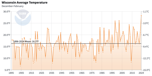
As you have heard a few times before, each day we calculate the areal extent of air colder than minus 5 degrees Celsius (23 degrees Fehrenheit) at 850 mb (about 1 mile above sea level) over the entire Northern Hemisphere.
This calculation can be used to assess the severity of the winter in a given year compared with other years stretching back to 1948. Each day from Dec. 24 through Dec. 30 of this season set the all-time minimum areal extent for that calendar day, meaning that the hemisphere was warmer over each day in that last week of December than it had been on those same days in any of the previous 77 years.
This is both remarkable and sobering as it indicates that, despite the local weather being quite wintry in some locations that don’t often see such extremity, the entire Northern Hemisphere is still clearly demonstrating the fact that the planet is warming.
What this means for the rest of the winter, both over the hemisphere and more locally in southern Wisconsin, is hard to say. However, the lack of snowfall to date in Madison will surely moderate the extreme cold that appears to be looming for midweek next week.
Steve Ackerman and Jonathan Martin, professors in the UW-Madison department of atmospheric and oceanic sciences, are guests on WHA radio (970 AM) at noon the last Monday of each month. Send them your questions at stevea@ssec.wisc.edu or jemarti1@wisc.edu.