Has there been a sudden stratospheric warming this year?

The stratosphere, which begins approximately 6 miles above the cold poles and 10 miles above the tropics, is where the temperature increases with altitude. Temperatures increase because ozone molecules in the stratospheric ozone layer absorb solar ultraviolet energy within the stratosphere. Air flow in the stratosphere is much less turbulent than in the troposphere. For this reason, jet aircraft pilots like to cruise at stratospheric altitudes so the flight is less bumpy. In polar regions, the top of the stratosphere extends upward to around 30 miles.

The polar vortex is a band of strong winds high in the atmosphere that spins counterclockwise around the North Pole. At the southern edge of the vortex is the polar jet stream, which separates warm air to its south from increasingly colder air to its north.

strong/stable polar vortex usually means strong polar circulation and jet stream. This locks the colder air into the Arctic Circle, creating milder conditions for most of the United States. In contrast, a weak/disrupted polar vortex creates a weak jet stream pattern. As a result, it has a harder time containing the cold air, which can now escape from the polar regions into the United States. (Image credit: NOAA Climate.)

A sudden stratospheric warming, or SSW, occurs in the winter, when the polar stratosphere warms and the winds that normally flow from west to east around the pole weaken dramatically and even reverse direction. This phenomenon occurs about six times per decade and leads to a breakdown of the polar vortex. SSWs can cause the polar night jet to weaken, which allows cold air near the polar cap to expand into the middle latitudes.

This year has seen an interesting arctic stratospheric pattern — a major SSW happened twice this year, once in mid-January and again at the end of February. These SSWs warm the arctic stratosphere and decelerate the polar vortex. This is really good news for arctic total ozone levels, since SSWs increase arctic ozone by large amounts and these high amounts persist into spring and summer, decreasing the amount of ultraviolet energy that can reach the surface.

Steve Ackerman and Jonathan Martin, professors in the UW-Madison department of atmospheric and oceanic sciences, are guests on WHA radio (970 AM) at 11:45 a.m. the last Monday of each month. Send them your questions at stevea@ssec.wisc.edu or jemarti1@wisc.edu.

Category: Phenomena, Severe Weather

Comments Off on Has there been a sudden stratospheric warming this year?

What is latent heat?

Since the beginning of the 2023-24 snow season, Madison and Dane County have received approximately 32 inches of snow.

Snow covered view of Wisconsin on January 17th, 2024 via VIIRS Today.

Snow is a form of solid water, and water is the only substance that occurs naturally in all three phases — solid, liquid and invisible gas — in the Earth’s atmosphere. Of course, that means that the 32 inches of snow began as the equivalent amount of water in the invisible vapor (gas) phase before it transformed into solid water.

Everyone knows that melting ice into liquid water requires energy. Not surprisingly, energy is also required to transform liquid water into water vapor, the familiar process of evaporation. The particular amounts of energy needed to accomplish these changes of phase are known as latent heats — the latent heat of melting for the first one and the latent heat of evaporation for the second.

When a cloud of invisible water vapor condenses into a puddle of liquid water, the latent heat of condensation (equal to the latent heat of evaporation) is released to the environment. Also, when that puddle freezes into ice the latent heat of fusion (equal to the latent heat of melting) is similarly released, incoherently, to the environment.

Since we know the depth of liquid equivalent precipitation involved in delivering us 32 inches of snow since Dec. 1, the area of Dane County and the latent heats of condensation and fusion, we can calculate how much energy has been released to the atmosphere in the production of that much snow. Without providing the details of the calculation, we can report that the amount of energy involved could power the entire Madison metro area for approximately seven years!

Clearly, there are huge amounts of energy involved.

Steve Ackerman and Jonathan Martin, professors in the UW-Madison department of atmospheric and oceanic sciences, are guests on WHA radio (970 AM) at 11:45 a.m. the last Monday of each month. Send them your questions at stevea@ssec.wisc.edu or jemarti1@wisc.edu.
Category: Meteorology, Seasons

Comments Off on What is latent heat?

Have we just seen the weirdest weather of the season?

National Weather Service Warnings and Reports. Tornado Warnings are in red, Severe Thunderstorm Warnings yellow, and Special Marine Warnings purple. (Image credit: NOAA/NWS-Sullivan)

The extremely unusual weather we have experienced this winter perhaps reached a new peak last Thursday when, in addition to remarkable springlike temperatures in the southern part of the state — Madison reached a high of 55 degrees while Milwaukee hit 59 — there were confirmed tornadoes in several southern counties: Dane, Rock and Green.

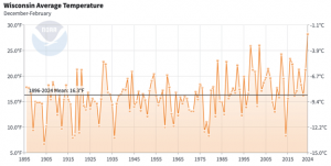
These are the first February tornadoes ever recorded in Wisconsin. And this means we are in absolutely uncharted weather and climate territory. What’s more, this strange weather is not limited to our region. In fact, thus far the entire Northern Hemisphere is running its fourth-warmest winter (Dec. 1 through Feb. 7) in the past 76, years and we have a genuine shot at being the warmest ever by the time this month is over.

Thus far in Madison, we recorded a December that was 9.5 degrees above normal, a January that was 3.5 degrees above normal (despite a frigid week near the middle of the month) and a first week of February that was 12.9 degrees above normal.

All together this means our winter has so far averaged 7.15 degrees above normal — stunning and disconcerting at the same time. If we continue to be so much warmer than normal and also remain relatively dry (we are about 0.3 inches below normal precipitation since Dec. 1), the soil will continue to dry out, leaving spring planting compromised.

Thus these weird weather happenings, not unlike the disastrous floods from last weekend in California, cast long shadows and continue to deliver unprecedented impacts as the climate slowly but inexorably changes.

Steve Ackerman and Jonathan Martin, professors in the UW-Madison department of atmospheric and oceanic sciences, are guests on WHA radio (970 AM) at 11:45 a.m. the last Monday of each month. Send them your questions at stevea@ssec.wisc.edu or jemarti1@wisc.edu.
Category: Uncategorized

Comments Off on Have we just seen the weirdest weather of the season?

What are folklore weather forecasts?

Humans have always needed weather forecasts. Farmers and sailors in particular needed to know if storms were approaching. People looked to their surroundings and observed nature and the world around them to try to predict the coming weather.

Over time, various folklore forecasts, often in the form of short rhymes, were devised and passed down through the generations. Although memorable, folklore forecasts are of uneven quality — some good, others laughably bad.

The forecast made on Groundhog Day is an example of predicting the weather based on folklore. If the groundhog comes out of its hole and sees its shadow, we are in store for 40 more days of winter. The predictions made by this folk forecast are correct only about 40% of the time — vastly inferior to what is delivered by modern science. If you flip a coin, you’ll be close to being correct 50% of the time. The popularity of Groundhog Day in the United States has much more to do with clever marketing than it does with forecast accuracy.

Another example comes from ancient mariners:

Red sky at night, sailor’s delight
Red sky at morning, sailor take warning.

Red sky at night! Credit: Benji Johnson

This saying is fairly accurate as it has some meteorologic basis. A clear western sky at sunset allows the sun to shine through the atmosphere, its light reddening as a result of Rayleigh scattering and then reflecting off clouds in the eastern sky. Clouds to the east usually move away; storms in the middle latitudes generally travel to the east under the influence of jet-stream winds.

The reverse is true in the morning, when the red sunlight shines on storm clouds approaching from the west. However, this folklore doesn’t work at all in overcast conditions or at tropical latitudes, where weather often moves from east to west.

Steve Ackerman and Jonathan Martin, professors in the UW-Madison department of atmospheric and oceanic sciences, are guests on WHA radio (970 AM) at 11:45 a.m. the last Monday of each month. Send them your questions at stevea@ssec.wisc.edu or jemarti1@wisc.edu.
Category: History, Seasons

Comments Off on What are folklore weather forecasts?

Are drones used in meteorology?

Unmanned aerial vehicles, or UAVs, have been used to make weather observations for half a century. Over the past decade there has been a wider application of drones in meteorology due in part to technological developments.

NASA takes retired Global Hawk military drones and sets them up to fly dangerous missions monitoring some of the most extreme storms for better weather data. (Photo credit: NASA)

Drones can provide critical research observations of weather systems. For about a decade, NOAA has partnered with NASA to fly the Global Hawk high-altitude unmanned aircraft to observe and study how hurricanes form and intensify. High-resolution photographs from low-flying drones are used to understand and document wind and flood damage associated with severe weather. They also help to better assess storm intensity based on the damage.

Routine integration of weather drones into weather forecasting would provide more precise monitoring of localized atmospheric conditions. However, restrictions on flight paths are one barrier to using drones in operational weather forecasting. Federal regulations prohibit drones from being deployed beyond visual line of sight. In addition, drones do not perform well in poor weather conditions. Swarm drone intelligence is also needed to coordinate multiple drones in sensing the boundary layer.

Drones with meteorological instruments, referred to as meteodrones, provide important observations of the lower atmosphere where there is a dearth of data, despite the importance of this boundary layer in weather forecasting. Drone systems are being developed to provide this data, as sustained observations of the boundary layer would improve local weather forecasting.

This spring, the World Meteorological Organization is planning a seven-month worldwide campaign to assess drones’ capability to improve weather forecasting. About 40 drone teams will coordinate and launch their drones to collect atmospheric observations in the U.S., Europe and Asia. The participants will share their data for analysis and study the impact of drone observations, along with established radiosondes and weather balloon data, on weather forecasting.

Steve Ackerman and Jonathan Martin, professors in the UW-Madison department of atmospheric and oceanic sciences, are guests on WHA radio (970 AM) at 11:45 a.m. the last Monday of each month. Send them your questions at stevea@ssec.wisc.edu or jemarti1@wisc.edu.
Category: Meteorology, Severe Weather

Comments Off on Are drones used in meteorology?