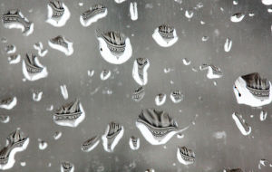
What is baseball’s longest streak of games being rained out?

Baseball fans in our area are likely quite pleased with the persistent success of the 2014 Milwaukee Brewers who lead the National League Central by 1.5 games as of this morning.

Since the opening of Miller Park in 2001, Brewers fans have also enjoyed the certainty that a scheduled game will not be postponed due to rain.

Last week was the 105th anniversary of a most unusual baseball record as on Aug. 18, 1909, the Philadelphia Phillies endured their 10th consecutive rainout.

This rainy day was in Philadelphia, but the team had just returned from a “western” trip that began in St. Louis, moved to Cincinnati and then on to Pittsburgh.

Two separate storms were apparently responsible for the remarkable streak of bad weather-luck.

The first storm was an unusual late-summer cyclone that affected the midsection of the country near the end of the first week of August.

Our guess is that storm was the kind we now call a “cut-off” cyclone – an upper-level weather disturbance that gets isolated from the main westerlies farther to the north.

Such storms can linger in a region for unusually long periods of time, produce persistent showery and heavier rain, and are reminiscent of the sort of prolonged bad weather that can occasionally ruin Memorial Day weekend here in southern Wisconsin.

The second storm may have been a weak tropical storm that redeveloped off the coast of the Carolinas and Virginia near the middle of the month.

The details of this streak of rainouts are not well-documented, but it is a fact that the Phillies were out of the pennant race by the time the streak began — they finished 36.5 games behind the Pirates but well ahead of the now (thankfully) forgotten Brooklyn Superbas and Boston Doves.

Category: Uncategorized

Comments Off on What is baseball’s longest streak of games being rained out?

What is a funnel cloud?

A funnel cloud gets its name from its shape — it is a funnel-shaped protuberance from the base of a thunderstorm.

It is composed of water droplets and is often associated with a supercell storm. The funnel cloud often has rotation, and when it does, it’s a harbinger of possible severe weather.

A supercell thunderstorm is a large storm, sometimes 20 miles or more across, that almost always produces dangerous weather.

Supercell storms produce one or more of the following weather conditions: strong wind gusts, large hail, dangerous lightning and tornadoes. The severity of these storms is primarily a result of the structure of the environment in which the storms form. Severe weather requires warm, moist air near the ground and a change in wind speed and direction, or wind shear, with height above the surface.

Funnel clouds are not dangerous unless they reach the ground. We are interested in reported funnel clouds since it is possible that a funnel cloud can become a tornado. If the rotating funnel cloud stretches down and touches the ground, it is called a tornado.

Many tornadoes are at one time funnel clouds, but not all funnel clouds become tornadoes. When a trained weather spotter observes a funnel cloud, he reports it to the National Weather Service, who may then warn the public.

Less threatening is a cold-air funnel. These are generally observed in partly cloudy skies after the passage of a cold front. While they look threatening, they don’t pose a hazard.

Category: Meteorology, Phenomena, Severe Weather

Comments Off on What is a funnel cloud?

Has this summer been mild?

This summer has been relatively mild, compared to some we have recently experienced.

In 2012 we recorded 39 days with a high temperature of 90 degrees or greater. This summer we have only had one such day so far — July 22, when the temperature was 93.

Tuesday is the 81st anniversary of the 127-degree high in 1933 at Greenland Ranch in Death Valley, California, that set the national record for the month of August. Such heat is of a completely different character than anything that has ever happened in and around Madison.

The all-time high for Madison was set on July 14, 1936, when the temperature soared to 107 degrees.

It is important to note that 107 here might be more uncomfortable than 127 in the desert, given that such a hot day in Madison is nearly always accompanied by very high humidity, while the desert is always very dry.

In fact, to get as hot as 127 degrees, even at Death Valley, special circumstances have to be met. Most importantly, there has to be a strong flow of air off of the surrounding higher terrain. This sinking air is compressed as it moves downward to higher pressures, and the compression leads to substantial warming. At the same time, this compressional warming lowers the relative humidity of the air, rendering it very dry as well.

Many of us experienced the extreme heat and humidity of July 13, 1995, when the temperature in Madison was 101 with a dew point of over 80 degrees – truly miserable. Still, the question of whether super hot and super dry is more uncomfortable than really hot and super humid is perhaps dependent on personal tolerance.

I think we can all be glad that we have not (yet) been put to that test this summer.

Category: Seasons

Comments Off on Has this summer been mild?

Why don’t we see rainbows at noon?

The classic rainbow is a single, brightly colored arc. Red is the outermost color of this arc, and violet is always innermost.

On occasion, you may see two rainbows at once. The lower rainbow is the primary rainbow, and the higher, more faintly colored arc is the secondary rainbow. The color sequence of the secondary rainbow is opposite to the primary; red is on the inside of the arc and violet is on the outside.

To form a rainbow you need large drops of water, the sun at your back and at the correct angle. Raindrops act as prisms, bending and reflecting the sunlight that falls on them; just like a crystal hung in a sunny window.

As light enters water, the path it takes changes. How much the direction changes is a function of the color of the light. You probably noticed that a smooth water surface can act like a mirror and reflect light.

If the light beam entering the raindrop reaches the back of the drop at a certain angle, it undergoes a reflection and heads back toward the sun. Sometimes the light reflects twice off the back of the raindrop; this leads to the secondary rainbow. As the light exits the raindrop and re-enters the air, its path bends an amount that again depends on the color. This bending of the light as it enters and leaves the drop disperses the light of the sun into its spectrum of colors that form the rainbow.

A rainbow is located opposite to the sun; this explains why rainbows are not seen at noon with the sun overhead. There needs to be a clear path from the sun to the rain falling from the cloud. If the sun is overhead and raining, you are probably standing in the rain with the cloud obscuring the sun.

Category: Phenomena

Comments Off on Why don’t we see rainbows at noon?

Is Lyme disease connected to the weather?

Scientists at the National Center for Atmospheric Research and the U.S. Centers for Disease Control recently explored the relationship between the reports of Lyme disease and weather observations. They found that warmer temperatures, higher humidity and less rain are correlated with an earlier start and peak of the Lyme disease season.

The start of the Lyme disease season begins in late May on average and lasts for about 14 weeks. An above average amount of precipitation from the start of the year tends to result in a later beginning of the Lyme disease season. An earlier start to the season is associated with more days with temperatures above 50 degrees, except for the most northern regions of the U.S.

Deer ticks carry Lyme disease and can infect humans when they bite us. The disease is found predominately in Wisconsin, Minnesota and the northeastern United States.

The ticks that commonly spread the disease develop faster with warmer temperatures, and they are more active in feeding with warmer temperatures, higher humidity and a lack of heavy precipitation. Of course, these are times many people seek the outdoors.

Weather conditions not only affect the tick life cycle and our outdoor habits, but also the population of the ticks’ primary host — the white-footed mouse. A dry summer can result in less vegetation that is the food supply for the mice. This can result in a reduced population of mice, reducing the tick population and thus the cases of Lyme disease.

The correlation between weather and the start of Lyme disease season is strong enough that one can forecast the start of the season by analyzing the daily temperatures for the first 10 weeks of the year. Unfortunately, there are few correlations that support predicting the end of a particular Lyme disease season.

Category: Seasons

Comments Off on Is Lyme disease connected to the weather?