
NOAA maintains observations of temperature and precipitation extremes in the U.S. The data indicate that cold extremes in the U.S. have become less frequent. Since the 1930s, there have been many more record-high temperatures compared to record-low temperatures. With warmer temperatures, the amount of precipitable water in the atmosphere also increases.
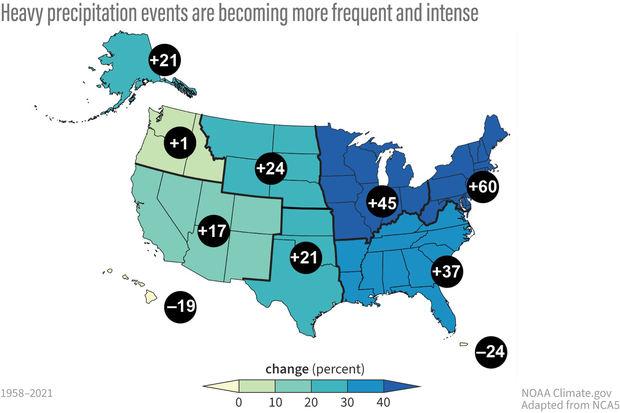
Consistent with the increased atmospheric moisture, rainfall and extreme precipitation events have also increased. Almost all areas in the U.S. exhibit increases in heavy precipitation, with the largest increases in the Midwest (45% increase) and Northeast (60% increase). The Northwest has the smallest increase (1%) increase followed by the Western regions (17% increase).
A rain day is defined as a period of 24 hours in which 0.01 inches or more of rain is recorded. The intensity of rainfall can be classified as: “light,” the rate of fall varying between a trace and 0.10 inch per hour; “moderate,” from 0.11 to 0.30 inch per hour; and “heavy,” 0.30 inch per hour.
Recent observations and studies suggest shifts in rainfall intensity. A recent study investigated daily precipitation intensity distribution from 1951–1980 and 1991–2020. They grouped the data for these two 30-year time periods according to 17 climate regions of the United States. Regions in the central and eastern U.S. show a consistent increase in average precipitation and its variability. Changes are mixed in the western U.S. The study also quantified a shift in the number of low precipitation events to the number of higher intensity events.
Changes in the rainfall distribution has implications for water management, agriculture, and potential flood risk. NOAA’s sustained observations and research are critical to observing and understating why extreme events are changing now and how they may change in the future.
Steve Ackerman and Jonathan Martin, professors in the UW-Madison department of atmospheric and oceanic sciences, are guests on WHA radio (970 AM) at noon the last Monday of each month. Send them your questions at stevea@ssec.wisc.edu or jemarti1@wisc.edu.