The surface of a lake exchanges energy with the air above. Cold air cools the lake surface through energy exchanges with the atmosphere, determined by the weather above. As cool surface water cools, it becomes denser than the warmer water below and so the cooled water sinks. Water from below then rises to the surface where it begins to cool.

What is unique about the H2O water molecule is that as liquid water cools, its density increases until about 39°F (4°C). At that point, the colder water becomes less dense, stays at the surface, and continues to cool. Once the surface water cools to approximately 32°F, the water molecules crystallize into interlocking lattice-like patterns and ice is formed. For a lake surface to freeze, the entire lake needs to be at a temperature of 39°F; only then as the surface cools will the temperature of the liquid water at the surface remain less dense than the water below and thus float and begin to form ice. Shallower lakes usually freeze before deeper lakes since shallower lakes contain less water that needs to be cooled.
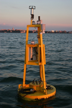
When a lake will freeze is not determined solely by cold autumn weather but also depends on the lake’s temperature throughout the year. If the lake warms more than average during the summer, it could take longer to cool because the entire lake must reach a temperature of 39°F. If you want to monitor Lake Mendota’s temperature (and other factors), data is provided to the public by the Lake Mendota Buoy (or David Buoy): https://metobs.ssec.wisc.edu/mendota/buoy, a service of UW-Madison.
A lake’s freezing date is the first date that most of the lake surface is estimated to be frozen. The Lake Mendota, Lake Monona, and Lake Wingra median freeze dates are December 20, December 15, and November 29, respectively.
Steve Ackerman and Jonathan Martin, professors in the UW-Madison department of atmospheric and oceanic sciences, are guests on WHA radio (970 AM) at noon the last Monday of each month. Send them your questions at stevea@ssec.wisc.edu or jemarti1@wisc.edu.

