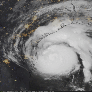
GOES-16 animation of Hurricane Harvey showing Clean Window IR (10.3 µm) and City Lights Background at night, True Color Imagery during the day, 1100-1900 UTC on 25 August 2017 (Photo credit: Space Science and Engineering Center, UW-Madison)
Hurricane Harvey is the first hurricane to make landfall in the United States since Wilma hit Florida in October 2005.
Harvey made landfall early Saturday morning as a Category 4 storm with estimated sustained winds of 130 mph and gusts to 150 mph.
Even in the face of these extreme winds, however, the largest fraction of the widespread damage associated with the storm is likely to be a direct result of the almost unimaginable amounts of rain that will fall with its passage across eastern Texas and Louisiana.
By the time the storm’s weakened remnants are forecast to leave the region on Wednesday, a number of locations are likely to have received more than 2 feet of rain, and some may even see 4 feet!
Needless to say, the ground cannot effectively absorb that much water in so short a time and so widespread flooding will be the rule in southeast Texas.
Millions of people will be adversely affected by this event, and it is only the beginning of what has been predicted to be a fairly vigorous Atlantic hurricane season.
It may surprise you to know that UW-Madison is a major contributor to national efforts to monitor and predict these powerful storms.
The Cooperative Institute for Meteorological Satellite Studies (CIMSS) has a research group within it dedicated to processing satellite remote observations so that they can be used in computer-based forecasts of these storms.
Since hurricanes develop over the vast tropical oceans, these satellite observations are the most comprehensive set of measurements available for these forecast models.
Without this Wisconsin connection, our ability to forecast these mercurial storms would be substantially less successful and many more people would be imperiled by their approach.
Steve Ackerman and Jonathan Martin, professors in the UW-Madison department of atmospheric and oceanic sciences, are guests on WHA radio (970 AM) at 11:45 a.m. the last Monday of each month.

