
Department of Environment, Land, Water and Planning, Gippsland, Australia)
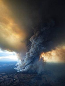
With the raging fires in Australia, you may have heard news reports of pyrocumulus, or fire clouds.
In Latin, pyro means “fire” and cumulus means “pile up.” Cumulus is a type of cloud that is common in Wisconsin, particularly in summer. Cumulus clouds are those puffy white clouds with tops that have a cauliflower appearance.
Pyrocumulus clouds are grayish or brown in color because of the ashes and smoke of the fire. The tops of these clouds can reach as high as 30,000 feet. It is difficult to locate the bottom of a pyrocumulus cloud as it is often obscure by the ash generated by the fire or the volcanic eruption.
A pyrocumulus cloud forms from rising air that results from intense heating of the surface by phenomena such as wildfires or volcanic eruptions. The fires that generate these clouds can be man-made or natural. A big fire produces strong upward moving air currents that carry water vapor and ash upwards. The water vapor can condense on the ash forming cloud drops. The vigorous upward motions produce these pyrocumulus clouds that look similar to thunderstorm clouds, which also form due to strong upward moving air.
If lots of water vapor is available, the pyrocumulus can develop into a cumulonimbus, or thunderstorm. When a thundercloud forms, it is called pyrocumulonimbus. Like thunderstorms, pyrocumulonumbus can produce lightning because of the strong updrafts. Rain can also fall from these clouds, which could help extinguish the fire generating the cloud. Of course, the lightning might cause another fire.
There have also been reports of fire tornadoes in the recent Australian fires. A fire tornado is a swirl of fire that extends upward from a ground fire. They are also called fire whirls. These vortices can occur over a range of fire sizes, but the largest are associated with wildfires like those in Australia.
There is a wide range in the properties of a fire tornado, but they are usually 30 to 200 feet tall and about 10 feet wide. Generally, they last for only a few minutes. Fire tornadoes were reported during the famous Peshtigo Fire of October 1871.
Steve Ackerman and Jonathan Martin, professors in the UW-Madison Department of Atmospheric and Oceanic Sciences, are guests on WHA radio (970 AM) at 11:45 a.m. the last Monday of each month.