Was July a record wet month?

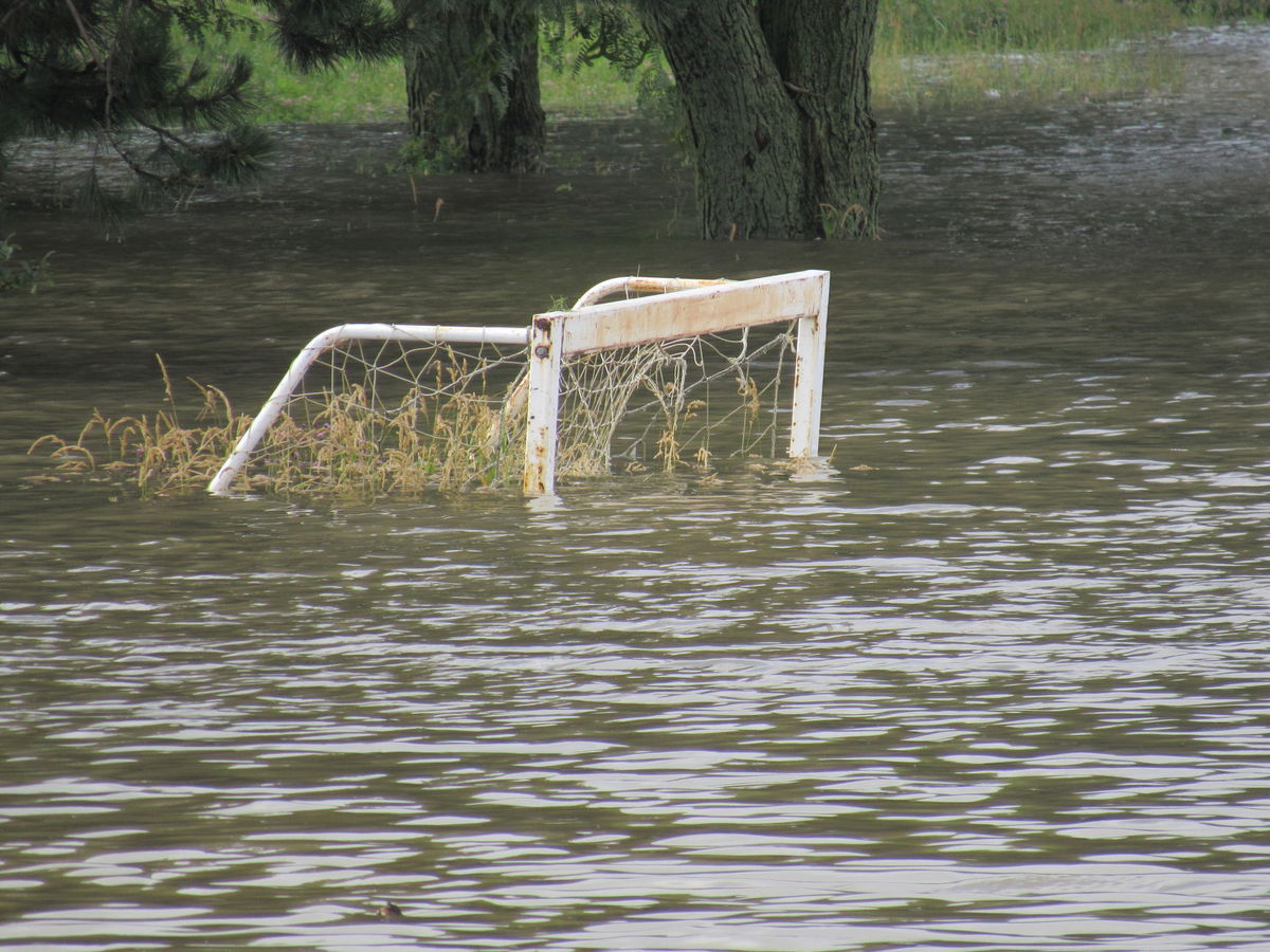
Heavy storms July 10 caused flooding around the Madison area, including partially submerging this soccer goal along Mineral Point Road near West Towne Mall. In total 6.52 inches of rain has fallen in Madison this month, 2.72 inches above normal. (Photo credit: Barry Adams, State Journal archives)

It seems likely that most of us would consider this month of July to be an exceptionally wet one and, in many ways, that is true.

First of all, we have received measurable rain on 11 days this month and a trace of rain on six other days. Thus, well over half of the days this month have involved precipitation.

In total, 6.52 inches of rain has fallen on Madison this month. With no more precipitation today, that would put us 2.72 inches above normal for July. So, it has been a rainy month – but not everywhere in Wisconsin.

For instance, Milwaukee has totaled only 3.69 inches this month, barely (0.35 inches) above its monthly average. Rhinelander has received only 1.62 inches of rain in July, which is a little more than 2 inches below its normal for the month.

As rainy as it has been in Madison, it has been even worse in La Crosse (7.63 inches, which is 3.78 inches above normal for July) and Chicago (7.68 inches, 4.40 inches above normal).

Of course, anyone who has been outside this month will also recognize it has been a mosquito-heavy month. This is directly related to the rainfall as nearly two dozen species of mosquitoes hatch during the summer, in serial fashion, so a prolonged wet summer tends to result in lots of bugs.

It could all be worse, though. In July 1950, Madison received 10.93 inches of rain, which is the record for the month.

That soggy July is not even the wettest month of the year in Madison, as the all-time wettest month here was August 2007 when 15.18 inches of rain fell.

Category: Meteorology, Seasons

Comments Off on Was July a record wet month?

Why does the sun melt ice on sidewalks even when the temperature is below freezing?

If a sidewalk is salted, ice may absorb the salt, which lowers its freezing point and may lead to melting. (Photo credit: Baraboo News Republic archives)

All objects exchange energy with their environment. They do this via conduction, advection, convection and radiation. If water is involved, a change in the water phase (liquid, solid or gas) also will involve an exchange of energy.

Conduction moves energy by physical contact. Convection results from hot air rising. Advection by the wind moves heat horizontally.

Radiative processes transfer heat throughout the entire atmosphere and into space. Radiation can be absorbed, reflected or transmitted. Convection and latent heating transfer heat over great distances through vertical motions and phase changes of water.

In the case of ice on a sidewalk, assuming the sidewalk has not been salted and there is no wind, the important energy exchange mechanisms are conduction and radiation. The ice is exchanging energy with both the sidewalk and the air around it via conduction.

If the atmosphere is below freezing, this will not result in the ice melting. If it is night time, and the sidewalk is below freezing, then this will not result in the ice melting. But during the day, the story could be different.

If the sun is shining on the ice, some of that solar energy will be absorbed. Ice is clear at visible wavelengths, the energy to which our eyes are sensitive. But the sun emits radiation at other wavelengths which water will absorb, and thus increases its energy gain.

If these gains exceed the energy losses, the ice will warm. If it reaches the melting point, the ice will start to melt. The sun can also add energy and warm the sidewalk, increasing its temperature to above freezing. This will then warm the ice via conduction and lead to its melting.

If the sidewalk has been salted, the ice may absorb the salt, which lowers its freezing point and may lead to melting.

Category: Meteorology, Seasons

Comments Off on Why does the sun melt ice on sidewalks even when the temperature is below freezing?

Is moist air lighter than dry air?

UW-Madison student Jessica Bjerke contends with an unruly umbrella while making her way across campus amid March’s high winds and cold rains. Moist air is lighter than dry air, which is composed mostly of nitrogen and oxygen molecules that weigh more than water molecules. (Photo credit: John Hart, State Journal archives)

Yes. Our air is primarily composed of nitrogen and oxygen, but it always has some water molecules.

The weight of an individual atom is represented by its atomic weight. The (rounded) atomic weight of hydrogen (H) is 1, oxygen (O) is 16, nitrogen (N) is 14, and carbon (C) is 12.

The weight of a molecule is determined by summing the atomic weights of its atoms. A water molecule (H2O) has a molecular weight of 18 (1 + 1 + 16). Free nitrogen (N2) has a molecular weight of 28, and an oxygen molecule (O2) has an atomic weight of 32. Therefore, a water molecule is lighter than either a nitrogen or an oxygen molecule.

Any fixed volume of a gas at constant pressure and temperature has the same number of molecules. It does not matter what the gas is — the same number of molecules will exist in that volume.

To make a given volume of air moister, we need to add water vapor molecules to the volume. To add water molecules to the volume, we must remove other molecules to conserve the total number of molecules in the volume.

Dry air consists mostly of nitrogen and oxygen molecules, which weigh more than water molecules. This means that when a given volume of air is made more moist by adding water molecules, heavier molecules are replaced with lighter molecules. Therefore, moist air is lighter than dry air if both are at the same temperature and pressure.

Category: Meteorology

Comments Off on Is moist air lighter than dry air?

Can weather fan the flames of revolution?

Thomas Jefferson, author of our Declaration of Independence and an avid weather observer, recorded a mild summer day with a high temperature of 76 degrees as we declared independence from Britain on July 4, 1776. (Official Presidential portrait of Thomas Jefferson by Rembrandt Peale, 1800)

July was the month of revolution in both America and France in the late 18th century as we declared independence from Britain on July 4, 1776, and the French Revolution began with the assault on the Bastille in Paris on July 14, 1789. It is interesting to examine the extent to which weather may have influenced the passions that led to these seismic events.

The author of our Declaration, Thomas Jefferson, was such an avid weather observer that he brought his instruments with him from Monticello to Philadelphia that summer. He recorded a mild day on July 4 with a high temperature of 76 degrees. Phineas Pemberton, a prominent citizen, independently recorded the same high temperature – nearly 10 degrees Fahrenheit below normal. Pemberton also noted a wind shift from northerly to southwesterly with a falling pressure as often accompanies passage of a surface high-pressure system. Thus, the great revolutionary act in America was birthed in benevolent weather conditions.

Not so for the French Revolution. The summer of 1788 had been exceptionally dry across the country and led to widespread crop failure. The hot, dry summer was followed by an unusually cold winter that made keeping warm more expensive. Food shortages brought on by the prior summer’s drought intensified in the spring of 1789 and left the populace, already frustrated with the opulence of Versailles, in a heightened state of agitation. Recent analysis by scholars at the London School of Economics has suggested that these conditions were a proximate cause to the civil unrest that led a mob of Parisians to storm the Bastille and, effectively, ignite the French Revolution.

Category: Meteorology, Severe Weather

Comments Off on Can weather fan the flames of revolution?

What causes a double rainbow?

A rainbow, with just a hint of a double rainbow above it, arches across a Madison field after a storm moves away. The view is looking east toward Downtown from a hill near Mineral Point Road and Highway M. (Photo credit: State Journal archives)

The classic rainbow is a single, bright, colored arc. Red is the outermost color of this arc, and violet is always the innermost color.

On occasion, you may have seen two rainbows at once. The lower rainbow is the primary rainbow and the higher, fainter, colored arc is the secondary rainbow. The color sequence of the secondary rainbow is opposite to the primary; red is on the inside of the arc and violet on the outside.

When sunlight passes through a triangular glass prism, it separates into the colors of the rainbow. This separation happens because different colors bend, or refract, by different amounts. The shortest (blue and violet) wavelengths refract the most; red light refracts the least.

The separation of colors is referred to as dispersion. Not only prisms but also water drops and ice crystals can cause dispersion. To form a rainbow you need large drops of water, the sun at your back and at the correct angle.

Raindrops act as prisms, bending and reflecting the sunlight that falls on them, just like a crystal hung in a sunny window.

As light enters water, the path it takes changes. How much the direction changes is a function of the color of the light.

You probably noticed that a smooth water surface can act like a mirror and reflect light. If the light beam entering the raindrop reaches the back of the drop at a certain angle, it undergoes a reflection and heads back toward the sun. As the light exits the raindrop and re-enters the air, its path bends an amount that again depends on the color. This bending of the light as it enters and leaves the drop disperses the light of the sun into its spectrum of colors that form the rainbow.

Sometimes the light reflects twice off the back of the raindrop; this leads to the secondary rainbow. The second reflection causes the order of the colors in the bow to reverse.

Category: Meteorology, Phenomena

Comments Off on What causes a double rainbow?