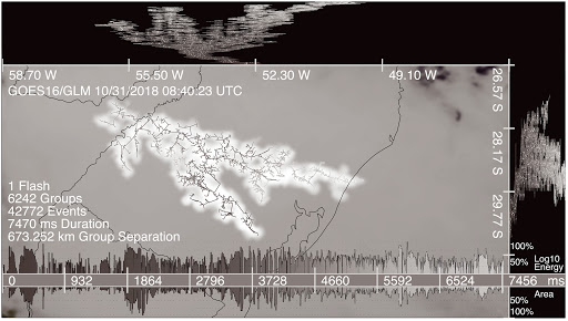
What is warm rain?

Warm rain is more common in places such as the Iao Needle, west of Wailuku, which is part of a moist, narrow valley in the center of West Maui, than in Madison. (Photo credit: Max Wanger, Hawaii Tourism Authority)

Warm rain results from the joining together of a cloud’s liquid water droplets. For the rain to be warm, temperatures throughout the cloud must be above freezing, so ice particles are absent.

Rainmaking is not easy. A single, small raindrop is a collection of about 1 million cloud droplets. A typical cloud droplet is usually 10 times smaller than the periods in this article.

One process to produce a large drop quickly is to combine many smaller particles. To form rain, the cloud droplets have to bump into each other and merge together through a process called collision and coalescence.

The process of combining cloud droplets through collision-coalescence is an important mechanism for forming precipitation in clouds composed solely of liquid water droplets.

Here’s how the process works. Water droplets of different sizes move at different speeds as gravity and vertical motions within the cloud act on them. The difference in speed increases the chance of collisions, as does any turbulent motions in the cloud.

Almost all precipitation particles that fall in Madison begin as ice particles, even in summer. The frozen particles completely melt, reaching the ground as raindrops, which means that rain is usually cold. In contrast, rain in Hawaii is typically warm rain, as the cloud top temperatures are typically below the freezing level.

Lightning requires frozen ice particles along with liquid droplets. Because most rain in Hawaii is warm rain, you rarely hear thunder in that state.

Category: Meteorology, Tropical

Comments Off on What is warm rain?

Why are there so few hurricanes every year?

This satellite image from the National Oceanic and Atmospheric Atmospheric Administration shows Hurricane Irma obscuring most of Florida in 2017. Even in a particularly active year, not many hurricanes actually develop. (Photo credit: NOAA)

We are about five weeks away from the climatological peak of the hurricane season, which stretches from early June to November.

During that period, even in a particularly active year, not many hurricanes actually develop. Forming over tropical oceans ensures that warm sea-surface temperature (SST) provides a mature hurricane with a means to warm and moisten the air that flows toward the important eye-wall convection. Thus, it is not surprising that hurricanes struggle to develop if the SST is not 79.7 degrees or warmer.

Tropical cyclones also require environments in which the wind speed and direction changes very little with increasing height, or where the vertical wind shear is small.

Certain vast stretches of the tropical ocean have SSTs above the threshold value of 79.7 degrees and thus qualify as locations where the development of tropical cyclones is favored. However, within such areas, it is only when the vertical shear is very low — from the surface to about 8 miles above the surface — that hurricanes can form and grow to maturity. In a given location in the tropics, it is much more likely that the shear condition, not the SST, will vary from one day to the next.

There are a number of physical factors that can conspire to render the vertical shear too extreme to allow for hurricane development. One such factor is the presence of the so-called subtropical jet stream, which is located between 20 degrees and 30 degrees latitude and about 8 miles above the ground in both hemispheres.

The subtropical jet stream is an ever-present feature of the general circulation of the tropics and has wind speeds routinely in excess of 130 mph. Such strong winds well above the surface are more than sufficient to provide a toxic amount of vertical shear to a nascent tropical cyclone. The small number of hurricanes every year testifies to the hostility of the environment to their development.

Category: Severe Weather, Tropical

Comments Off on Why are there so few hurricanes every year?

What is with the hot temperatures in Europe?

Temperature anomalies across Europe (departures from normal) measured by satellite in late June.

Europe recorded its hottest June ever.

The hottest temperatures occurred June 26-28, resulting from a high-pressure system that settled over Europe combined with hot winds from the Sahara Desert in Africa. France observed temperatures in excess of 113 degrees for the first time since temperatures were recorded.

The global average temperature of June 2019 was the highest measure for the month of June in the 140-year National Oceanic Atmospheric Administration (NOAA) global temperature record. The NOAA measurements also show that the January-June temperature for 2019 is the second-warmest January-June on record.

Europe is on its way to recording one of the hottest Julys on record also. The June heat wave was followed by another heat wave at the end of July. Five countries set new all-time national heat records. The Netherlands, Belgium, United Kingdom, Luxembourg and Germany reached new temperature records of 102.7, 107.2, 100.6, 105.4 and 108.7, respectively. The new records in Belgium and Luxembourg exceeded the old records by more than 5 degrees. Last week Germany, France and Belgium each saw record-breaking temperatures at cities throughout the country, beating record temperatures set in the 1940s.

The high temperatures can cause various materials to expand, causing travel problems for commuters and holiday travelers. The high temperatures affect road conditions. Expanding concrete doesn’t have enough room to expand and can buckle. Or, slabs can push against one another and crack. Under hot conditions, tarmac can melt.

The hot weather can lead to cancellations or delay of trains, as the heat can cause train tracks to buckle or signals to fail. Hundreds of Eurostar passengers from Brussels to London were stuck for hours in 104-degree heat when their train broke down in a tunnel.

Steve Ackerman and Jonathan Martin, professors in the UW-Madison Department of Atmospheric and Oceanic Sciences, are guests on WHA radio (970 AM) at 11:45 a.m. the last Monday of each month.
Category: Meteorology, Weather Dangers

Comments Off on What is with the hot temperatures in Europe?

What is a heat wave?

A heat wave is a period of abnormally and uncomfortably hot and usually humid weather.

The World Meteorological Organization is specific in its definition by stating that a heat wave is when the daily maximum temperature for more than five consecutive days exceeds the average maximum temperature by 9 degrees Fahrenheit.

By that definition, Madison — which would have to see 91 degrees for five consecutive days, given its average maximum temperature of 82 — did not have a heat wave last week, though temperatures hit at least 85 for nine days (July 12 through Saturday) and all but two days were 88 or higher.

Heat waves are caused by very hot, stagnant air masses. Regions that suffer under intense hot spells are usually dominated by a surface high-pressure system with a mid-tropospheric ridge aloft. Dew points are also high, and to compound matters, wind speeds are often low. Clear or partly cloudy skies allow intense solar energy to further heat the ground and the air mass.

High humidity and stagnant air reduce the body’s ability to cool down through sweating. Lives are endangered when these conditions persist day and night for several days. Each summer in the United States, approximately 175 to 200 deaths are attributable to heat waves. Most of these deaths occur in cities, particularly northern cities.

Heat waves also have a big economic impact. A prolonged heat wave can cause the widespread use of air conditioning, leading to increased demands for power that stress gas and electric utilities. Transportation can be stymied when highway surfaces and railways buckle and warp in the heat. All types of outdoor work, such as landscaping and construction, experience reduced productivity. Agriculture is especially vulnerable as heat waves stunt crops and can kill livestock.

The National Weather Service issues excessive heat warnings within 12 hours of the onset of extremely dangerous heat conditions. This warning is generally issued when the maximum heat index temperature is expected to be 105 degrees or higher for at least two days and nighttime air temperatures will not drop below 75. Madison’s heat index hit 109 on Friday and 102 on Saturday, with nighttime lows of 78 and 66.

These criteria for issuing a warning vary across the country, especially for northern regions which are not used to hot, humid conditions.

Steve Ackerman and Jonathan Martin, professors in the UW-Madison Department of Atmospheric and Oceanic Sciences, are guests on WHA radio (970 AM) at 11:45 a.m. the last Monday of each month.
Category: Uncategorized

Comments Off on What is a heat wave?

Did the moon landing influence weather forecasting?

Astronaut Buzz Aldrin Jr. stands next to the Passive Seismic Experiment device on the surface of the moon on July 20, 1969, during the Apollo 11 mission. The space race was responsible for enormous advances in satellite technology. (Photo credit: Neil Armstrong)

On Saturday, we will mark the 50th anniversary of humankind’s first-ever footsteps on a different world, the lunar landing of Apollo 11.

The moon landing represented the peak of the Cold War’s space race and, though motivated by martial competition between geopolitical adversaries, the drive to reach the moon produced a large number of technical advances which most of us take for granted today.

With specific respect to weather forecasting, the space race was responsible for enormous advances in satellite technology that now provide the backbone of the global observations of the atmosphere required to power the weather prediction enterprise.

Another extremely important aspect of the prediction revolution was the rapid development of computer technology. Despite the fact that your mobile phone has more computing power than the entire array of machines available to Mission Control in July 1969, the Apollo program drove the development of smaller and more powerful computers.

Finally, the Apollo program provided inspiration to thousands of young boys and girls who were fortunate enough to see, at an early age, what science really is — a grand adventure of exploration and discovery. One of us (Martin), still retains vivid memories of making the first footprints in the newly fallen snow of a New England blizzard while delivering morning newspapers and imagining himself as Neil Armstrong. That sense of kinship with a hero of exploration likely fueled more than one young person’s desire to pursue the wonders of science.

Category: Climate, Meteorology

Comments Off on Did the moon landing influence weather forecasting?