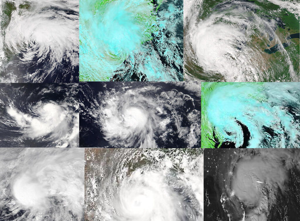
When is the autumnal equinox?

The harvest moon, shown in 2015, isn’t defined by any change in its color, but rather by the time of year it arrives — closest to the autumnal equinox. This year’s autumnal equinox occurred this morning. (Photo credit: John Hart, State Journal)

This morning we officially entered fall as the autumnal equinox occurred at 2:50 a.m.

That means that today, in common with every location on Earth, we will enjoy exactly 12 hours of daylight and 12 hours of night.

Of course, 12 hours of daylight in Madison (43 degrees north latitude) is substantially different than 12 hours of daylight at the North Pole (90 degrees north latitude) where the Sun will barely be visible above the horizon for the 12 hours of “daylight.”

On Tuesday, the sun will not appear above the horizon at the Pole and will not come back for six months.

As the days march on, the same fate will gradually overtake other latitudes in the Northern Hemisphere until by Dec. 21, the sun will not rise even at 66.5 degrees north latitude.

The primary means by which air is warmed is by its contact with the surface of the Earth that, when the sun shines, can absorb radiation and heat up.

A leading consequence of the shortening days, especially at high latitudes, is that air masses can begin to get really cold again. Even as we enjoy a rather warm September, the areal extent of the cold wintertime air is growing at high latitudes.

As it encroaches southward from the Pole, the polar jet stream, always on the warm edge of the coldest arctic air, begins to take up residence at lower latitudes bringing with it the powerful storms of late autumn and winter.

So, enjoy the beautiful early fall days we are likely to have this week in Madison because the cosmic deck is stacked against us!

Category: Meteorology, Seasons

Comments Off on When is the autumnal equinox?

What is the hurricane cone of uncertainty?

A hurricane map’s cone of uncertainty is developed from computer forecast models by the National Hurricane Center and shows the most likely path of a hurricane’s eye. President Donald Trump stirred controversy when he claimed that Hurricane Dorian could possibly threaten Alabama. (Photo credit: Evan Vucci, Associated Press)

Starting in the 1950s and up until the 1980s, meteorologists forecast the path of hurricanes using statistical prediction based on past data and current climatological data.

Today, weather computer models are primarily used for the forecasting.

The National Hurricane Center (NHC) issues 120-hour, 96-hour, 72-hour, 48-hour, 24-hour and 12-hour forecasts. The NHC forecasts include the hurricane track, intensity, size, along with rainfall and storm surge.

Once a hurricane has formed, scientists track the storm and predict its path using three- to five-day forecasts. Different models are used to predict the path of the hurricane. More than one model is used, as well as multiple forecasts from the same model with slightly different conditions.

The various hurricane forecast models create objective, computer-simulated predictions of a hurricane’s path and intensity. Each of these models will predict slightly different storm tracks.

The cone of uncertainty represents the probable track of the center of the hurricane, based on the models used to make the forecast. The cone represents the uncertainty in the forecast of the storm’s center, not necessarily the areas that will experience impacts.

The NHC produces many different graphic products and text messages each day. The graphics, including the cone of uncertainty, is used to communicate the model output to the public.

The cone of uncertainty should be used to get a rough idea of where the storm center may go, and the current wind watches and warnings for coastal areas.

The hurricane forecast models have improved, and continued improvements are expected. The track of the hurricane is better predicted than its intensity. Predicting the intensity accurately remains an outstanding challenge of meteorology.

Steve Ackerman and Jonathan Martin, professors in the UW-Madison Department of Atmospheric and Oceanic Sciences, are guests on WHA radio (970 AM) at 11:45 a.m. the last Monday of each month.
Category: Meteorology, Severe Weather, Tropical

Comments Off on What is the hurricane cone of uncertainty?

Can we modify hurricanes?

There have been a few theories for how humans might be able to dissipate a hurricane, though they all have downsides. (Photo credit: NOAA)

There have been several suggestions on how humans might modify the intensity or path of a hurricane.

One method suggested was to change the “energy budget” of the environment around the storm. It was suggested that this could be done by dispersing, from aircraft, carbon soot. That soot would absorb solar energy and warm the atmosphere, which would enhance the evaporation of ocean water and promote the formation of thunderstorms.

Those thunderstorms, if they formed in the correct place, could weaken a cyclone’s eye wall. You can imagine why that is not a favorable approach.

For one, the sediment, which would fall out of the atmosphere and onto the ocean quickly, would be messy.

Another is the cost of sending planes out to do this and the amount of carbon needed to affect the environment. How would we be assured that the thunderstorms formed in the correct place? Moreover, even if this was practical, it would only work during the day.

Another approach, first suggested in the late 1950s, was the use of nuclear bombs.

Hurricanes get their energy from evaporation of warm ocean water. Exploding a nuclear bomb in the ocean would bring cooler water to the surface, reducing the fuel for the hurricane. If dropped in the eye of the hurricane, it was theorized that a nuclear explosion could push warm air up and out of the storm’s eye, cooling the storm center and causing it to dissipate.

While nuclear bombs are terribly destructive, the energy in a nuclear bomb pales in comparison to nature’s tropical storms. The heat released by a hurricane is equivalent to a 10-megaton nuclear bomb exploding every 20 minutes. So, nuking a hurricane very likely wouldn’t do much to diminish it, although it might make it radioactive — another downside.

Other methods proposed include using mechanical pumps to bring cooler ocean water to the surface and seeding the storm with silver iodide to accelerate cloud formation and dry out the storm precipitation.

Rather than trying to modify the path or intensity, it is probably wiser to be prepared for its arrival.

Category: Meteorology, Severe Weather, Tropical

Comments Off on Can we modify hurricanes?

What is fulgurite?

Lightning is an atmospheric discharge of electricity that is five times hotter than the surface of the sun. When lightning strikes the ground, it is hot enough to fuse silica sand and clay together into fulgurites: shafts of glass produced by lightning. The word fulgurite comes from fulgur, the Latin word for thunderbolt.

Fulgurite: hollow, glass-lined tubes with a sandy outside, aka “petrified lightning”. 
Source: Discover Magazine

Glass can be made by heating sand, which is mostly silicon dioxide, or quartz. The lightning bolt vaporizes the sand it encounters, generating a hollow tube. As the heat moves outward from the entry hole, the sand grains melt and form a smooth inner surface. As the heat moves further outward, it fuses grains of sand.

The outside is rough, looking like petrified lightning when the fulgurite has branching assemblages. But the inside is hollow and smooth. The composition of the sand determines the color of the fulgurite.

Fulgurites are very fragile, as they are hollow and have lots of air spaces. They can get longer than 10 feet, although most are a few inches. Since they trap air bubbles, old fulgurites can be used to study the composition of air in ancient times. Additionally, the number of fulgurites found along with the date formed can provide information on the frequency of lightning.

The Libyan Desert is pure white sand composed of quartz. Fulgurites have been found in that desert. Also discovered were pieces of fused quartz with the clarity of clear glass. Such a piece adorns the mummified body of Tutankhamen. The piece is estimated to have formed 26 million years ago. To form such a piece of glass requires very hot temperatures, hotter than lightning. The most reasonable theory is that this was formed by a high-energy impact of a meteor.

Steve Ackerman and Jonathan Martin, professors in the UW-Madison Department of Atmospheric and Oceanic Sciences, are guests on WHA radio (970 AM) at 11:45 a.m. the last Monday of each month.
Category: Phenomena

Comments Off on What is fulgurite?

Do storms impact Arctic sea ice?

Researchers look out from the Finnish icebreaker MSV Nordica as the sun sets over sea ice in the Victoria Strait along the Northwest Passage in the Canadian Arctic Archipelago. The occasional extreme late-summer storm can be quite damaging to the ice. (Photo credit: David Goldman, Associated Press Archives)

As we head into the second half of August the days are noticeably shorter. That change is even more dramatic in the polar regions where the summer ice melt season is nearing its end.

This year’s melt has been particularly dramatic, with the Arctic sea-ice extent likely heading to its lowest level since satellite measurements began in 1979. The previous low extent record was set in 2012.

The sea-ice is subject to a number of different processes that can force its melting in summer. A good deal of those processes are tied to the progression of late-summer storms over the ice.

Though most such storms are too weak to do excessive damage to the ice, the occasional extreme late-summer storm can be quite damaging for two reasons. First, the extreme storms have very strong winds associated with them and those winds can break up the ice edge through the action of large waves. The resulting small rafts of ice easily melt away in the surrounding water.

Second, the storms have extensive cloud canopies associated with them. The composition of these clouds — whether they are mostly liquid water droplets or ice crystals -– has a large impact on the amount of radiation they emit toward the ice. Liquid water clouds emit more radiation toward the ice than ice crystal clouds and therefore contribute to more melting.

Whether a cloud canopy is mostly liquid water or ice crystals may be directly related to the way in which the storm itself is generated. At UW-Madison we are getting involved in a project that seeks to take measurements in the Arctic in the summer of 2021 to learn more about these interesting and impactful storms.

Category: Meteorology, Seasons

Comments Off on Do storms impact Arctic sea ice?