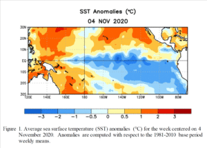
How did 2019 weather align with climate trends?

Government scientists concluded that the globally averaged temperature for 2019 was 1.71 degrees Fahrenheit above the 20th-century average and 2.07 degrees above the 19th-century average. This is the 43rd consecutive year that the global temperature was above the 20th-century average.

This was the second-highest since record keeping began in 1880 and was just 0.07 degrees less than the record value set in 2016. Nine of the 10 warmest years have occurred since 2005, and the five warmest years have occurred since 2015.

Overall, North America’s temperature was 1.62 degrees above the 1910–2000 average, marking the 14th-warmest year. Record high annual temperatures were measured across parts of central Europe, Asia, Australia, New Zealand and southern Africa.

The average annual temperature for the contiguous U.S., which doesn’t include Alaska or Hawaii, was 52.7, or 0.7 degrees above the 20th-century average. This ranked in the warmest third of the record and was the coldest year since 2014. Wisconsin’s annual average temperature ranked 46th in the record.

The contiguous U.S. average annual precipitation was 34.78 inches, 4.84 inches above the long-term average. The year 2019 was the second-wettest year on record. Wisconsin, along with North Dakota, South Dakota, Minnesota and Michigan, had its wettest year on record in 2019.

Also, 2019 saw the continued trend in the decline of Arctic sea ice extent. The average annual sea ice extent in the Arctic was approximately 3.94 million square miles, the second-smallest in the 1979-2019 record. This continues a trend of sea ice loss of about 18,000 square miles per year. That is more than a quarter of the size of Wisconsin.

Over the 41-year satellite record of sea ice coverage in December, the Arctic has lost about 734,000 square miles of ice — 11 times the size of Wisconsin. The extent of sea ice around the Antarctic was also the second-smallest annually averaged value on record.

Steve Ackerman and Jonathan Martin, professors in the UW-Madison Department of Atmospheric and Oceanic Sciences, are guests on WHA radio (970 AM) at 11:45 a.m. the last Monday of each month.

Category: Climate, Meteorology

Comments Off on How did 2019 weather align with climate trends?

What is a fire cloud?

Massive smoke rises Jan. 2 in East Gippsland, Victoria, as wildfires ravage Australia’s eastern coast. A pyrocumulus cloud forms from rising air that results from intense heating of the surface by phenomena such as wildfires or volcanic eruptions. (Photo credit:
Department of Environment, Land, Water and Planning, Gippsland, Australia)

With the raging fires in Australia, you may have heard news reports of pyrocumulus, or fire clouds.

In Latin, pyro means “fire” and cumulus means “pile up.” Cumulus is a type of cloud that is common in Wisconsin, particularly in summer. Cumulus clouds are those puffy white clouds with tops that have a cauliflower appearance.

Pyrocumulus clouds are grayish or brown in color because of the ashes and smoke of the fire. The tops of these clouds can reach as high as 30,000 feet. It is difficult to locate the bottom of a pyrocumulus cloud as it is often obscure by the ash generated by the fire or the volcanic eruption.

A pyrocumulus cloud forms from rising air that results from intense heating of the surface by phenomena such as wildfires or volcanic eruptions. The fires that generate these clouds can be man-made or natural. A big fire produces strong upward moving air currents that carry water vapor and ash upwards. The water vapor can condense on the ash forming cloud drops. The vigorous upward motions produce these pyrocumulus clouds that look similar to thunderstorm clouds, which also form due to strong upward moving air.

If lots of water vapor is available, the pyrocumulus can develop into a cumulonimbus, or thunderstorm. When a thundercloud forms, it is called pyrocumulonimbus. Like thunderstorms, pyrocumulonumbus can produce lightning because of the strong updrafts. Rain can also fall from these clouds, which could help extinguish the fire generating the cloud. Of course, the lightning might cause another fire.

There have also been reports of fire tornadoes in the recent Australian fires. A fire tornado is a swirl of fire that extends upward from a ground fire. They are also called fire whirls. These vortices can occur over a range of fire sizes, but the largest are associated with wildfires like those in Australia.

There is a wide range in the properties of a fire tornado, but they are usually 30 to 200 feet tall and about 10 feet wide. Generally, they last for only a few minutes. Fire tornadoes were reported during the famous Peshtigo Fire of October 1871.

Steve Ackerman and Jonathan Martin, professors in the UW-Madison Department of Atmospheric and Oceanic Sciences, are guests on WHA radio (970 AM) at 11:45 a.m. the last Monday of each month.

Category: Meteorology, Phenomena, Severe Weather, Weather Dangers

Comments Off on What is a fire cloud?

Was December’s unusual warmth widespread?

Golfers take advantage of December’s unseasonably warm temperatures during the “Ugliest Christmas Sweater Golf Scramble” at The Oaks Golf Course in Cottage Grove, WI on Dec. 22.
(Photo credit: Shanzeh Ahmad, State Journal Archives)

Despite the slight touch of winter on its last morning, December 2019 was an unusually warm month both locally and hemispherically.

Here in Madison, the month averaged 7 degrees above normal, with the highest temperature of the month, 55, occurring on Christmas Day, just one degree shy of the all-time daily record.

Across the entire Northern Hemisphere, the areal extent of air colder than 23 degrees at approximately 1 mile above the ground was the smallest ever in the 72-year record. It is nearly impossible to say what this exceptionally warm month means for the rest of the winter, especially locally.

Any of us who have lived here long enough know that winter has a way of making its presence felt even when off to a slow start. No matter what happens next in southern Wisconsin, we have passed what is normally a hard-hitting winter month relatively unscathed.

Hemispherically, there may be a bit more predictability given the warm December. Seven of the prior top 10 warmest Decembers have also ended up in the top 10 warmest winters (December, January and February). Two made modest rallies from 12th and 16th warmest Decembers to end up in the top 10 warmest winters. The outlier was the winter of 2001-02 which started off as the 48th warmest December and ended up as the 9th warmest winter.

Conversely, 1979-80 was, prior to this year, the second warmest December and yet ended up as only the 30th warmest December/January/February. Thus, though not a guarantee, it is very likely that this year the hemisphere will experience one of its five warmest winters in the past 72 years, yet another sign of the robustness of the gradual warming being observed in a number of other ways around the globe.

Steve Ackerman and Jonathan Martin, professors in the UW-Madison Department of Atmospheric and Oceanic Sciences, are guests on WHA radio (970 AM) at 11:45 a.m. the last Monday of each month.

Category: Climate, Seasons

Comments Off on Was December’s unusual warmth widespread?

What is freezing fog?

Just before Christmas the region was visited by the curious winter phenomenon known as freezing fog.

Freezing fog simultaneously covers the landscape with an ephemeral coating of rime ice while testifying to the curious chemical properties of water.

Fog, like most clouds, is composed of tiny liquid water droplets. In fact, fog is quite literally a cloud that hugs the ground.

Water can remain in the liquid state at temperatures below 32 F (the freezing point), especially if the liquid water particles are small. Such liquid water droplets are known as supercooled water droplets.

Clouds are filled with such supercooled water droplets. In fact, the presence of such droplets in clouds is the reason why aircraft icing occurs because when the droplets make contact with the wing of the plane, the droplets freeze.

When fog develops in environments with temperatures below the freezing point, the fog droplets can be supercooled. When supercooled water droplets make contact with objects whose temperatures are below 32 F, the water freezes.

Snow and freezing fog in Wisconsin
Photo credit: Dave Jones

Thus, as supercooled fog droplets are carried through the atmosphere by the light breezes that accompany fog, they strike tree branches, sidewalks, windshields, etc. and coat these objects with tiny shards of ice.

The longer the freezing fog exists, the more substantial becomes the cloak of ice on the surrounding objects. If you see the sun peeking through the fog while the trees are still coated with the rime ice, you will be treated to a most stunning winter landscape.

If, on the other hand, you are trying to travel, your attention should be directed to the delays that freezing fog is almost certain to compel.

Steve Ackerman and Jonathan Martin, professors in the UW-Madison Department of Atmospheric and Oceanic Sciences, are guests on WHA radio (970 AM) at 11:45 a.m. the last Monday of each month.

Category: Uncategorized

Comments Off on What is freezing fog?

Why don’t the latest sunrise and earliest sunset match up with the winter solstice?

The winter solstice has the shortest daylight hours of the year and will occur at 10:19 p.m. CST on December 21, 2019.

On that day we have our shortest day and longest night of the year in terms of daylight. It’s the astronomical moment when the sun reaches the Tropic of Capricorn.

However, for Madison this year, the earliest sunset occurred on Dec. 8, while the latest sunrise will occur on Jan. 3. So, the winter solstice doesn’t correspond to the latest sunrise or the earliest sunset.

Dawns early light over Lake Mendota and the UW-Madison on December 15, 2019.

The time when the sun reaches its highest point in the sky is called solar noon. One solar day is the time it takes for the sun to return to its highest point in the sky. The period from one solar noon to the next is called the solar day. Solar noon rarely occurs exactly at noon; it’s sometimes before or after.

If you take a picture of the sun each day when your watch says noon, the sun is not always in the same place in the sky. It moves east and west because of the variation in the length of the solar day, and it moves north and south with the change of the seasons. The combination of these motions traces out a figure-8 shape called the analemma, which is sometimes printed on globes.

The length of the solar day is determined mostly by the rotation of the earth on its axis, but is also weakly affected by the revolution of the earth around the sun. It changes throughout the year because the earth’s axis is tilted with respect to its orbit around the sun, and the earth’s orbit is an ellipse.

The longer-than-average solar day around the solstices causes both earliest sunset and latest sunrise to not fall on the solstice. The time from solar noon to sunset doesn’t change very much near the winter solstice. Therefore, since solar noon is a little later each day, sunset is also a little later each day. But because sunset is a little later each day, the earliest sunset has already occurred.

Similarly, later solar noons at the solstice imply later sunrises, hence sunrise is getting later and the latest sunrise is yet to occur. But because sunset is a little later each day, the earliest sunset has already happened. Similarly, later solar noons at the solstice imply sunrise is getting later and the latest sunrise is yet to occur.

Steve Ackerman and Jonathan Martin, professors in the UW-Madison Department of Atmospheric and Oceanic Sciences, are guests on WHA radio (970 AM) at 11:45 a.m. the last Monday of each month.

Category: Meteorology, Seasons

Comments Off on Why don’t the latest sunrise and earliest sunset match up with the winter solstice?