What is the status of the ozone hole?

The ozone hole is a region where there is severe depletion of the layer of ozone — a form of oxygen — in the upper atmosphere that protects life on Earth by blocking the sun's ultraviolet rays. (Image credit: NASA)
The ozone hole is a region where there is severe depletion of the layer of ozone — a form of oxygen — in the upper atmosphere that protects life on Earth by blocking the sun’s ultraviolet rays. (Image credit: NASA)

Ozone occurs about 18 miles above the Earth’s surface.

Ozone is both caused by and provides protection from damaging ultraviolet energy emitted by the sun. The development of an atmospheric “ozone layer” allowed life to move out of the oceans and onto land.

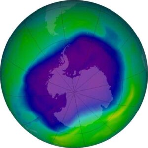
The amount of ozone in the atmosphere is routinely measured from satellites. Typically, the Antarctic ozone hole has its largest area in early September and lowest values in late September to early October. This year it was measured to be one of the largest and deepest in recent years, covering just over 9 million square miles.

The ozone hole occurs high over the continent of Antarctica. It is the appearance of very low values of ozone in the stratosphere. The winter atmosphere above Antarctica is very cold. The cold temperatures result in a temperature gradient between the South Pole and the Southern Hemisphere middle latitudes, which results in strong westerly stratospheric winds that encircle the South Pole region.

These extremely cold temperatures inside the strong winds help to form unique types of clouds called Polar Stratospheric Clouds, or PSCs. They begin to form during June, which is wintertime at the South Pole. Chemicals on the surface of the particles composing PSCs result in chemical reactions that remove the chlorine from the atmospheric compounds. When the sun returns to the Antarctic stratosphere in the spring (our fall), sunlight splits the chlorine molecules into highly reactive chlorine atoms that rapidly deplete ozone. The depletion is so rapid that it has been termed a “hole in the ozone layer.”

The Montreal Protocol bans emissions of ozone-depleting chemicals, and that is having a good impact. Observations show the area of the ozone hole is decreasing.

Category: Phenomena, Seasons

Comments Off on What is the status of the ozone hole?

What is a waterspout?

There are two types of waterspouts: fair weather waterspouts and tornadic waterspouts.

A fair weather waterspout is a whirlwind that forms beneath a cumulus cloud and over water. It’s generally not associated with thunderstorms.

A fair weather waterspout develops on the surface of the water and moves upward. Before you see the waterspout, you may see a funnel cloud hanging from the bottom of the cumulus cloud. A waterspout forms as the rotating funnel draws up water.

Fair weather waterspouts form in light wind conditions so they tend to stay in one place.

The Florida Keys, Gulf of Mexico, and Chesapeake Bay are common regions for waterspouts.

Waterspout on Lake Ontario in September 2020. Photo credit: Spencer Russell

They also occur over the Great Lakes. Between Sept. 28 and Oct. 4, 2020, there were 232 waterspouts over the Great Lakes. There was also another waterspout outbreak this year on the Great Lakes between Aug. 16 and Aug. 18, when the count was 88 spouts.

These large outbreaks resulted from a cold Canadian air mass moving over the Great Lakes. That increased the normal drop in temperature with height, making the air near the surface more prone to rising.

Severe thunderstorms that produce tornadoes that form over water or move from land to water become tornadic waterspouts. Tornadic waterspouts develop in the thunderstorm and move downward towards the ground.

Most fair weather waterspouts are much weaker than the weakest tornado. However, if you are in a boat and see one you should consider it dangerous. You can try to move away by steering your boat at right angles to its movement. If you can’t get out of the way, put on your lifejacket (which you should already have on) and protect yourself from flying debris.

Category: Meteorology, Phenomena

Comments Off on What is a waterspout?

Do the Rocky Mountains influence our weather?

Our string of beautiful days at the end of last week were related, believe it or not, to the presence of the Rocky Mountains hundreds of miles to our west.

The U.S. Rocky Mountain range via satellite.

Last week, the atmospheric flow at levels just above the mountains’ height was oriented almost directly across the high terrain. In such a case, like water flowing over a pebble in a stream, the air is forced to sink on the downwind — or lee — side of the mountains. As air sinks, it moves to higher pressures and is compressed. Upon being compressed, the air warms. Thus, whenever the flow above mountain height is directed as it was last week, very warm temperatures develop over Nebraska and the Dakotas.

The resulting warm air is then pushed eastward by the winds and is dragged toward the Great Lakes in a process known as “warm air advection.” On Friday that warm air advection was very strong and led to a high temperature for the day of 79 degrees. If not for some wispy high clouds early in the afternoon on Friday, we may well have reached 80 degrees or higher.

The last time Madison was officially 80 degrees or warmer was Sept. 2. The earliest day on which Madison has ever recorded its last 80-degree day of the year was Sept. 2, 1977. Thus, since the mercury stopped at 79 on Friday, we now have a very good chance of tying that unusual record — even though the early fall has been very pleasant.

Just for completeness, the all-time latest 80-degree day in Madison’s history is Oct. 23 so, if we fail in the first quest, perhaps we can succeed in overturning the second.

Steve Ackerman and Jonathan Martin, professors in the UW-Madison Department of Atmospheric and Oceanic Sciences, are guests on WHA radio (970 AM) at 11:45 a.m. the last Monday of each month.

Category: Meteorology, Seasons

Comments Off on Do the Rocky Mountains influence our weather?

Why are cold snaps in autumn so short-lived?

Early tinges of autumn color appear on a maple tree Thursday along Arboretum Drive in Madison. It can get cold in October, but typically not for long. (Photo credit: John Hart, State Journal)

Over the past weekend southern Wisconsin experienced its first cold snap of the season with widespread morning lows in the lower 30s on Friday and Sunday mornings.

Very often cold snaps in the autumn are very short-lived as this recent example was, affecting usually one or two nights at most.

There are a variety of reasons for this brevity.

First, cold snaps at this time of year require a substantial southerly excursion of cold air from high-latitude Canada to get us cold.

Though the Arctic night creeps ever farther south each day after the autumnal equinox, its southerly progress is slow.

Consequently, cold air production is limited to the very highest latitudes well into November, which means that any cold air that makes it as far south as Madison is not well-connected to a broader reservoir of cold air that would allow the cold to remain.

Second, there is little snow on the ground even in central Canada at this time of year and so the cold air that does migrate southward is modified (warmed) to a greater degree on that migration at this time of year than in the late fall and winter, when snow cover is widespread.

Third, the lack of snow on the ground in Madison itself limits the longevity of cold snaps. That’s even true in the wintertime.

Overnight cooling over a snowfield can reinvigorate the chill of a cold snap and render it longer-lasting as a result.

So, if you were complaining about the cold this weekend, be glad we are still in October and much more likely to experience a quick rebound.

Category: Meteorology, Seasons

Comments Off on Why are cold snaps in autumn so short-lived?

How does weather affect fall colors?

The bright red and purple colors of autumn leaves come from anthocyanin pigments, which are made from leftover glucose trapped within the leaves of some trees, such as maples. (Photo credit: La Crosse Tribune archives)

Astronomical fall began on Sept. 22.

Climatologists consider fall as the months of September, October and November. The fall season is also associated with pumpkin patches, fresh apples and beautiful foliage.

Leaves are green in the summer because they contain chlorophyll, which reflects green light more than other colors. Other colors are absorbed by chlorophyll for photosynthesis.

During autumn, the green chlorophyll disappears from the leaves as the leaves stop their food-making process, and yellow and orange colors appear. These colors have been in the leaves all along but we can’t see them in the summer because of the chlorophyll.

The color orange comes from carotene, and the yellows from xanthophyll. The bright red and purple colors come from anthocyanin pigments, which are made from leftover glucose trapped within the leaves of some trees, such as maples.

Brilliant fall colors with bright red and purple colors require conditions in which leaves can make a lot of anthocyanin pigments. The brilliance of a fall color season is a function of the weather.

Sunny days and cool nights are the key weather ingredient for brilliant fall colors. The best weather conditions are bright sunny days and cool, but not frosty, nights.

A drab autumn has lots of cloudy days and warm nights. Leaves begin to turn before we have any frosts. An early frost speeds up the fall of the leaves and brings a quick end to the fall color. A few hard frosts can cause the leaves to wither and fall from the tree without changing color.

Many southern Wisconsin regions have not experienced frost. Of course, too much winds, or heavy precipitation would bring the leaves down.

The pandemic has reduced the travel plans of many. But this weekend might be a good time to go for a ride to see the colors.

Category: Phenomena, Seasons

Comments Off on How does weather affect fall colors?