Another example of unprecedented weather extremes

Enhanced image of Hurricane Fiona from the GOES-East weather satellite, Sept 23, 2022. (Image credit: NOAA)

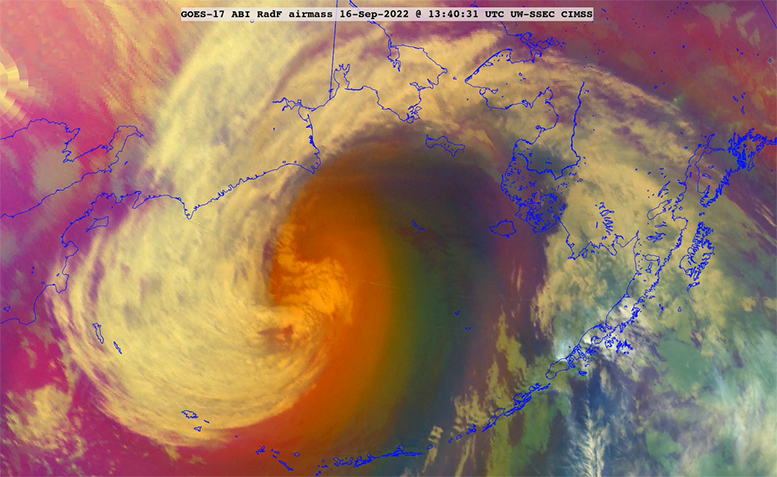
Another entry in the category of unprecedented weather extremes comes from the tropical Atlantic basin where, last week, Hurricane Fiona wrought devastation to the Commonwealth of Puerto Rico, still reeling from its assault by Hurricane Maria eerily precisely five years earlier.

Fiona dropped upwards of 30 inches of rain on the south shores of Puerto Rico before heading north into the Atlantic, where it systematically strengthened into a Category 4 hurricane with sustained winds of more than 130 mph.

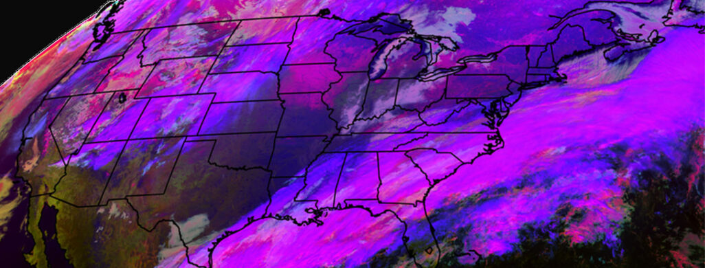
As Fiona was strengthening, the weather here in southern Wisconsin underwent a welcome change from the extreme humidity of Monday and Tuesday to the much drier, fall-like conditions of the late part of the week. This change was afforded by the passage of a fairly strong autumn cold front — on the first full day of fall. That same cold front was part of a larger extratropical weather system over eastern North America that was heading eastward to a rendezvous with Fiona as she left the tropics.

Embedded within the extratropical storm was a feature known as a tropopause fold. Such features were first observed only in the mid-1950s and, for a long while thereafter, were thought to be very unusual features, bordering on curiosities. Subsequent work has shown that these folds are ubiquitous features of the mid-latitude flow and, in fact, account for the creation of some of the ingredients needed for the development of all extratropical weather systems.

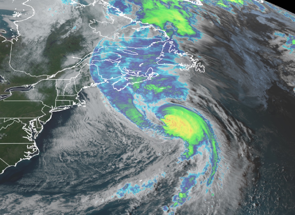
The fold associated with the storm that cooled us off by Wednesday was unusually strong for this time of year. When it encroached on Fiona north of Bermuda, the combination led to a dramatic reinvigoration of Fiona, as an extratropical cyclone, that slammed into Nova Scotia on Saturday, recording the lowest sea-level pressure ever observed in Canada.

So, for two weeks in a row, the atmosphere has served up remarkable examples of the havoc that can result from vigorous interaction between the tropics and the extratropics.

Steve Ackerman and Jonathan Martin, professors in the UW-Madison department of atmospheric and oceanic sciences, are guests on WHA radio (970 AM) at 11:45 a.m. the last Monday of each month. Send them your questions at stevea@ssec.wisc.edu or jemarti1@wisc.edu.

Category: Meteorology, Phenomena, Severe Weather, Tropical

Comments Off on Another example of unprecedented weather extremes

What can happen to hurricanes when they move into the mid-latitudes?

GOES West Air Mass RGB image of Ex-Typhoon Merbok in the Bering Sea on September 16th. (Image Credit: CIMSS Satellite Blog)

Hurricanes are large-scale, organized storms that form in the tropical latitudes.

They are fueled by the enormous amount of heat released when water vapor, evaporated off the warm tropical ocean surface, changes phase to liquid and ice in the thunderstorm clouds of the hurricane.

They are smaller in areal extent than the storms that commonly affect us in the mid-latitudes here in Madison.

The distribution of clouds and precipitation in a hurricane is usually symmetric about its center (the eye). This is vastly different from the characteristically asymmetric distribution of clouds in our more familiar extratropical cyclones.

Despite their tropical origin, hurricanes do find their way to the mid-latitudes with regularity, especially in the western Pacific Ocean basin. When they make this excursion they often undergo a dramatic restructuring that, in concert with interactions from the wavy flow of the mid-latitudes, can lead to powerful extratropical storms.

Such a situation occurred on Friday and Saturday when former Typhoon Merbok migrated from the tropics toward the central Bering Sea and became a devastating extratropical cyclone with 50 foot seas and wind gusts exceeding 80 mph.

Such extratropical transitions are most frequent in September and October in the Northern Hemisphere and can have global ramifications for the weather and its predictability. In the present case, there is a very good chance that extreme rainfall in central California in the middle of this week may be one result of Merbok’s dramatic conversion.

Steve Ackerman and Jonathan Martin, professors in the UW-Madison department of atmospheric and oceanic sciences, are guests on WHA radio (970 AM) at 11:45 a.m. the last Monday of each month. Send them your questions at stevea@ssec.wisc.edu or jemarti1@wisc.edu.

Category: History, Meteorology, Severe Weather

Comments Off on What can happen to hurricanes when they move into the mid-latitudes?

What is the difference between mist and fog?

In 2021, the GOES-R Fog and Low Stratus satellite product became operational in National Weather Service offices across the country. Helping airlines and passengers avoid costly delays and warning smaller aircraft of potential danger. (Image credit: Corey Calvert, CIMSS)

Both a mist and a fog are water droplets suspended in the atmosphere in the vicinity the earth’s surface that affect visibility.

They both differ from a cloud only in that the base of a fog or a mist is at the earth’s surface, while a cloud’s is above the surface.

The difference between a mist and a fog is associated with the atmospheric visibility. A fog and a mist are both composed of microscopic water droplets or wet hygroscopic particles suspended in the air. Particles cause light to be refracted and reflected in many directions, reducing visibility.

By international definition, a fog reduces visibility to below 1 kilometer (5/8 of a mile), while a mist occurs when the visibility at the earth’s surface is greater than 1 kilometer. These visibility observations are made at ground or sea level.

A fog is denser and thicker than a mist. Consequently, it is more difficult to see through a fog than a mist. A mist dissipates more quickly than a fog. In addition, the term “mist” is used in weather reports when the corresponding relative humidity is between 95% to 100%.

Haze is a related but slightly different phenomenon. Haze is a suspension of extremely small particles in the air, reducing visibility by scattering light like a fog and a mist. Haze formation is caused by the presence of an abundance of condensation nuclei which may grow in size, due to a variety of causes, and become a mist, a fog or a cloud.

Steve Ackerman and Jonathan Martin, professors in the UW-Madison department of atmospheric and oceanic sciences, are guests on WHA radio (970 AM) at 11:45 a.m. the last Monday of each month. Send them your questions at stevea@ssec.wisc.edu or jemarti1@wisc.edu.

Category: Meteorology, Weather Dangers

Comments Off on What is the difference between mist and fog?

Does lightning add nitrogen to the soil?

Our bodies need nitrogen to make proteins. The atmosphere’s composition is 78% nitrogen, but the nitrogen in the air is not available to our bodies.

GOES-East Geostationary Lightning Mapper (GLM) imagery over the southeast U.S. in April 2022

The two atoms in the airborne nitrogen molecule are held together very tightly. For our bodies to process that nitrogen, the two atoms must separate.

We obtain nitrogen from protein-containing foods in our diet. For example, plants absorb nitrates in the soil. When we eat plants, we get the nitrogen in a form that our bodies can use.

Plants also cannot make use of the nitrogen in the atmosphere. Fertilizers are one way to add nitrogen to the soil so that plants can use it.

Lightning is another way to get nitrogen into the soil.

Lightning is a huge electrical discharge that results from vigorous motions that occur in thunderstorms. Charges form in a storm composed of ice crystals and liquid water drops. Winds inside the storm cause particles to rub against one another, causing electrons to be stripped off, making the cloud particles either negatively or positively charged.

The charges get grouped in the cloud, often negative charges near the bottom of the cloud, and positive charges up high. This is an electric field, and because air is a good insulator, the electric fields become incredibly strong. Eventually a lightning bolt occurs to neutralize the electric field.

Bolts of lightning are powerful enough to break the strong bonds of the nitrogen molecule in the atmosphere. Once split, the two nitrogen atoms quickly bond to oxygen in the atmosphere, forming nitrogen dioxide. Nitrogen dioxide dissolves in water and forms rain droplets in the storm cloud, creating nitric acid, which forms nitrates.

The raindrops that carry the nitrates to the ground seep into the soil, where it can be absorbed by plants.

Steve Ackerman and Jonathan Martin, professors in the UW-Madison department of atmospheric and oceanic sciences, are guests on WHA radio (970 AM) at 11:45 a.m. the last Monday of each month. Send them your questions at stevea@ssec.wisc.edu or jemarti1@wisc.edu.

Category: Meteorology, Phenomena, Severe Weather

Comments Off on Does lightning add nitrogen to the soil?

What is energy’s relationship with rain?

Many locations across the country (and the world) have been experiencing unusually heavy rainfalls this summer.

Overshooting tops, gravity waves, lightning and outflow boundaries in this 2021 moonlit satellite image conveys some of the energy in a single summer thunderstorm complex.

Though in Madison we have had a relatively benign month of August in terms of temperature and humidity, we have still managed to find ourselves 2.09 inches above normal for rainfall for the month prior to Sunday’s rain.

That monthly surplus is almost entirely accounted for by the extremely heavy rainfall on Wednesday night/Thursday morning when 1.86 inches of rain fell at the Dane County Regional Airport — our largest daily total since July 5 and second largest of the summer.

Rain is the liquid form of water, the only substance that occurs naturally in all three phases — solid, liquid and invisible gas — in the Earth’s atmosphere. The 1.86 inches of rain Wednesday/Thursday began as an equivalent amount of water in the invisible vapor (gas) phase before transformed into liquid.

It may come as no surprise that energy (600 calories) is required to transform 1 gram of liquid water into 1 gram of water vapor, the familiar process of evaporation. An exactly similar amount of energy is released into the environment when 1 gram of invisible water vapor condenses into a puddle of liquid water.

The particular amounts of energy needed to accomplish these changes of phase are known as latent heats — the latent heat of evaporation for the first one and the latent heat of condensation for the second. Since we know the depth of accumulated liquid precipitation involved in our recent heavy rain event, the area of Dane County, and the latent heat of condensation, we can calculate how much energy was released to the atmosphere in the production of that much rain.

Without providing the details of the calculation, we can report that the amount of energy involved in just that one rain event could power the entire Madison metro area for approximately 3.9 years. Clearly, there are huge amounts of energy involved.

Steve Ackerman and Jonathan Martin, professors in the UW-Madison department of atmospheric and oceanic sciences, are guests on WHA radio (970 AM) at 11:45 a.m. the last Monday of each month. Send them your questions at stevea@ssec.wisc.edu or jemarti1@wisc.edu.

Category: Meteorology, Severe Weather

Comments Off on What is energy’s relationship with rain?