How do raindrops form?

Raindrops form when microscopic water droplets bump into each other in clouds. The more turbulent the clouds, the bigger the raindrops get.

Raindrops form when microscopic water droplets bump into each other in clouds. The more turbulent the clouds, the bigger the raindrops get.

To explain how this process works, let’s consider water droplets in the upward-moving air of a cloud. Water droplets in clouds with different sizes move at different speeds, as gravity and vertical motions within the cloud act on the particles. The difference in speed increases the chance of collisions, just as the combination of fast trucks and slow cars increases the chance of collisions on a highway. Turbulent motions in the cloud can also cause the droplets to collide.

The process of combining cloud droplets through collision-coalescence is an important mechanism for forming precipitation in clouds composed solely of liquid water droplets.

Aggregation is the process by which ice crystals collide and form a single larger ice particle. In the summer, the collections of crystals may form in the cloud but then melt as they fall to the ground, forming rain. When an ice crystal falls through a cloud, it may collide with and collect supercooled water droplets. This process is called accretion and is a mechanism to quickly form large particles.

How big a droplet or crystal grows depends on how long it stays in the cloud. The longer a particle is in the cloud, the more particles it can collect and the larger it grows. The strength of the vertical motions and the thickness of the cloud determine how long it stays in the cloud. This is why only tall clouds with strong updrafts, such as thunderstorms, produce large precipitation particles.

Category: Meteorology

Comments Off on How do raindrops form?

How do you stay safe from lightning?

Lightning can be fun to watch but it is also very dangerous.

Approximately 300 people are injured by lightning each year, and about 62 people are killed. On average there is about one death caused by lightning in Wisconsin annually.

While your chances of getting hit by lightning are only about 1 in a million in a given year, it is good to keep some safety tips in mind.

Lightning generates thunder so remember the saying: “When thunder roars, go indoors.” If you are outside and hear thunder, you are at risk and should seek shelter in a large building or enclosed vehicle. You are not safe anywhere outdoors. A house is a completely safe place to be during a lightning storm but stay away from anything that conducts electricity like plumbing, metal doors and TV cables.

If you are caught outside during a storm, you should run to a building or hard-topped vehicle — not a convertible. Most cars are a safe place to be, but not because of the rubber tires. It is the metal roof and metal sides that protect you, not the tires. If lightning were to strike the car, the energy would go through the metal frame into the ground. So don’t lean on the doors.

If caught outside with no access to buildings or cars, there is little you can do to substantially reduce your risk of getting struck. You should avoid open fields and ridge tops, stay away from tall isolated trees, and, if in a group, spread out. If someone in your group were to get struck, they are not electrified. If you touch them, you will not be electrocuted as the body does not store electricity. You should see if they need resuscitation like CPR.

Wisconsin gets hit by lightning about 300,000 times a year, mostly during the spring and summer. That’s about five flashes for each square mile in the state.

Don’t take chances with lightning. Stay safe by having a safety plan.

Category: Phenomena, Severe Weather, Weather Dangers

Comments Off on How do you stay safe from lightning?

Who was Professor Suomi?

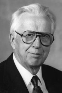
Verner SuomiVerner Suomi was a professor at UW-Madison and is known as the “father of satellite meteorology” because of his historic role in defining that field of study.

In the late 1950s, he and Robert Parent, a UW professor of electrical engineering, developed an instrument to measure the Earth’s heat balance from a satellite. It was the first successful satellite mission to make measurements of Earth.

In 1963, he designed the Spin-Scan Cloud Camera, a milestone in satellite instrumentation that flew throughout the 1960s, providing high-quality images of the Earth’s surface and atmosphere. These instruments laid the foundation for how to image weather for the world’s operational weather satellites.

He proposed the instrument to measure the atmosphere’s temperature and water vapor distribution from a geostationary satellite. These were measurements that became available in the 1980s.

Professor Suomi also directed the development of McIDAS, a computer software system designed to analyze and interpret the big data sets generated from satellite observations. This software, first developed in the early 1970s and maintained for over 40 years, remains a primary tool for analysis of satellite weather observations in forecasting centers and universities across the globe.

Earth wasn’t his only interest. Professor Suomi was a member of the Venus/Mercury 1973 Imaging Science Team, NASA’s Mariner/Jupiter/Saturn Imaging Science Team and the Pioneer Venus Science Steering Group.

Professor Suomi received many honors during his scientific career.

Recently, NASA named a satellite after him – the Suomi National Polar-orbiting Partnership Satellite.

Professor Suomi’s scientific accomplishments defined the young field of satellite meteorology.

His leadership in the development of satellite weather observations and analysis led to weather forecasting improvements that benefited Wisconsin, the nation and the world — the Wisconsin Idea in action.

Steve Ackerman and Jonathan Martin, professors in the UW-Madison department of atmospheric and oceanic sciences, are guests on WHA radio (970 AM) at 11:45 a.m. the last Monday of each month.

Category: Meteorology

Comments Off on Who was Professor Suomi?

What are straight-line winds?

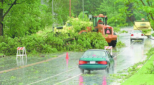
In May of 2000, authorities said straight-line winds uprooted trees as large as 5 feet in diameter. This tree that fell across Lacy Road near Richardson Road in Fitchburg was about 50 feet away from a home on Eugene Court that had its roof partially ripped off.

In May of 2000, authorities said straight-line winds uprooted trees as large as 5 feet in diameter. This tree that fell across Lacy Road near Richardson Road in Fitchburg was about 50 feet away from a home on Eugene Court that had its roof partially ripped off.

The lack of rotation, or spin, in these winds allows meteorologists to differentiate damage from tornadic winds. Tornadoes scatter objects all over because they rotate so quickly.

Straight-line winds can be hazardous as they can push over objects that can land on top of people, causing injury and death. In July 1999, straight-line winds blew down trees in forested areas of northwest Wisconsin. Many areas had wind speeds of greater than 60 mph, with some exceeding 100 mph.

Thunderstorms have upward air motions, called updrafts. These supply warm moist air to the storm and help to form the precipitation. There are also downdrafts, or sinking air in a storm. Such downdrafts carry air from high elevations in the atmosphere rapidly to the ground. Since wind speed is nearly always much faster at high elevations, the downdrafts carry very high momentum air to the surface, creating the straight-line winds.

Downdrafts also carry liquid water with them. When these downdrafts hit a region of dry air, such as below the cloud base, the drops evaporate. This cools the air in the downdraft, making it denser and thus causing the air in the downdraft to fall to the ground faster. You can sometimes notice this blast of cool air at the surface, often before it rains.

Category: Meteorology, Severe Weather, Weather Dangers

Comments Off on What are straight-line winds?

Why does it smell good after a rain?

Photo by John Hart, State Journal archives.  Elisha Rosas, left, and Carla McCants till soil in a community garden near the Goodman Community Center on Madison's East Side. The pleasant, musky aroma after a rain is similar to what gardeners smell when they turn over their soil.

Photo by John Hart, State Journal archives. Elisha Rosas, left, and Carla McCants till soil in a community garden near the Goodman Community Center on Madison’s East Side. The pleasant, musky aroma after a rain is similar to what gardeners smell when they turn over their soil.

Many times after a rain, there is a distinctive odor in the air — a sort of musky smell. This pleasant fragrance is most common in rains that follow a dry spell.

The phenomenon is referred to as petrichor, from the Greek roots petra (stone) and ichor (the blood of gods in Greek mythology). If you are a gardener, you may find this smell similar to the smell you sense when you turn over your soil. Good organic soils contain bacteria, and a bacterium that is abundant in damp warm soils is actinomycete.

Actinomycetes are a key ingredient in the decomposition of organic materials in the soil.

They thrive when the soil is moist. When the soil dries out, the actinomycetes produce tiny spores. These spores are part of their reproduction cycle.

Rain kicks up these spores when the raindrops hit the ground and make them airborne. Air movements then disperse the spores and carry some of the spores to our nose, where we detect an aroma.

Actinomycetes are very common, which is why you experience the after-the-rain smell in many locations. Oil exuded by certain plants during dry periods also contribute to the smell.

You may have noticed that petrichor is more common after light rains than heavy rains. High-speed photography has shown that light rain results in small bubbles in the rain drop at the soil surface that can transport microbes from the soil when the bubble burst.

Category: Meteorology, Phenomena

Comments Off on Why does it smell good after a rain?