Was Hurricane Beryl a special storm?

All hurricanes are special, given the extensive damage they can cause when they make landfall. Beryl was considered extra special because it was a record-breaking storm.

Hurricane Beryl gained 95 mph in less than two days, a process known as rapid intensification. (Image credit: NOAA)

Beryl rapidly intensified from a tropical storm to a major hurricane (Category 3 or higher) with wind speeds that increased to 95 mph in less than two days. Category 3 storms have sustained winds between 111 mph and 129 mph. Only six other Atlantic Basin storms have intensified this quickly and those storms all happened after August, the typical time of year with conditions favorable for hurricanes.

Beryl is the earliest Category 4 or 5 hurricane on record. It set the record for the earliest Category 4 (sustained winds of 130 mph to 156 mph) by more than a week, breaking the record set by Hurricane Dennis on July 8, 2005. It is the easternmost major hurricane to form in the month of June. Beryl is the only Category 4 hurricane in the Atlantic Basin to occur in June and only the third Category 3 Atlantic Basin hurricane to occur in June.

Beryl also broke the record for the earliest Category 5 hurricane by more than two weeks. Category 5 hurricanes have sustained winds of 157 mph or higher. Hurricane Beryl was deemed Category 5 on July 1, breaking the record set by Hurricane Emily on July 17, 2005. Beryl is the strongest July Atlantic hurricane ever measured.

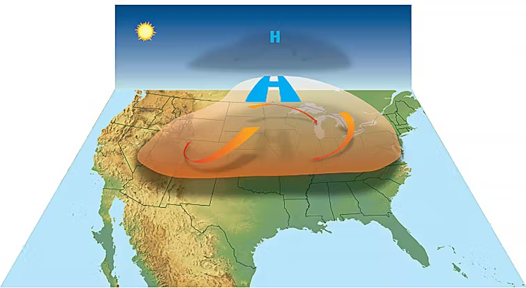
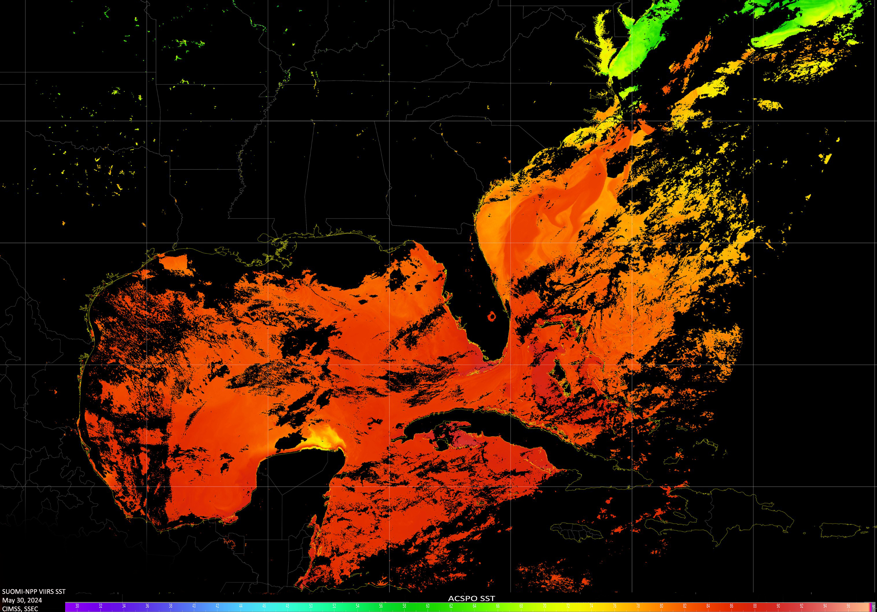
Forecasters expect the 2024 hurricane season to be one of the busiest seasons on record. This is due to the ocean water temperatures being so warm at this time of year. Warmer waters support stronger hurricanes. A La Niña pattern is predicted to develop later in the season, which makes the atmosphere more supportive for hurricanes and could also steer more storms toward the U.S.

Steve Ackerman and Jonathan Martin, professors in the UW-Madison department of atmospheric and oceanic sciences, are guests on WHA radio (970 AM) at noon the last Monday of each month. Send them your questions at stevea@ssec.wisc.edu or jemarti1@wisc.edu.

Category: History, Tropical

Comments Off on Was Hurricane Beryl a special storm?

What is a heat dome?

“Heat dome” is a term used by the news media to explain extreme heat conditions across large geographic regions.

The American Meteorological Society maintains a glossary of meteorological terms and added the term “heat dome” and this definition in March 2022: “An exceptionally hot air mass that develops when high pressure aloft prevents warm air below from rising, thus trapping the warm air as if it were in a dome.”

Heat domes involve high-pressure areas that trap and heat up the air below.  (Image credit: NOAA)

This is not the same as a heat wave, which is a spell of three or more abnormally hot days.

A heat dome develops when a ridge of high pressure builds over an area and resides there for a week or more. High pressure is associated with very few clouds and lots of sunshine, leading to warm temperatures near the surface. The sinking motion in the high pressure prevents warm air near the surface from rising. This motion causes further warming of the air by compression. Unless the upper atmospheric pattern changes, the high pressure will continue to exacerbate the hot conditions. The ground also warms and loses moisture, which can lead to drought conditions and the risk of wildfires. The term “heat dome” may also be used in describing drought events.

Hot and humid conditions can lead to heat-health issues. The heat index indicates how hot it feels. The index is calculated using an equation that is a function of air temperature and the relative humidity. The heat index is sometimes referred to as the “feels-like” temperature.

When our bodies get hot, we cool down by sweating. The sweating does not directly cool our bodies — it is the evaporation of the sweat that cools us down. If the air has a high humidity, then the rate of evaporation is reduced. This hampers the body’s ability to maintain a nearly constant internal body temperature.

Steve Ackerman and Jonathan Martin, professors in the UW-Madison department of atmospheric and oceanic sciences, are guests on WHA radio (970 AM) at 11:45 a.m. the last Monday of each month. Send them your questions at stevea@ ssec.wisc.edu or jemarti1@wisc. edu.

Category: Meteorology, Seasons, Severe Weather

Comments Off on What is a heat dome?

What is the largest hailstone on record?

A hailstone was found in Vigo Park, Texas, on June 2 that measured 7¼ inches in diameter.

The 1.9-pound hailstone was 8 inches in diameter and fell on July 23, 2010, near Vivian, South Dakota. (Photo credit: NWS)

However, that is not the record size hailstone for the U.S. That prize stone fell on July 23, 2010, near Vivian, South Dakota. It was 8 inches in diameter and weighed just over 1.9 pounds. The official record hailstone for Wisconsin fell in Wausau in 1921 and measured 5.7 inches. The world’s heaviest hailstone weighed 2.25 pounds and fell in Bangladesh in April 1986. Its diameter was not recorded.

Growth of large hail requires strong upward motions and an abundant supply of supercooled water. A hailstone of 4.5 inches needs at least 100 mph of updraft to keep it suspended in the storm. Eventually, though, the weight of the hailstone overcomes the strength of the updraft, and the stone falls to earth.

When a hailstone is cut in half, you can see rings of ice. Some rings are milky white; others are clear. This ringed structure indicates that hailstones grow by two different processes: wet growth, represented by the clear layers, and dry growth, which forms the milky white layers. The number of layers gives an indication of how many times the hailstone cycled through the storm.

Dry growth of hailstones occurs when the air temperature is well below freezing. In these conditions, a water droplet freezes immediately as it collides with the hailstone. This quick freezing leads to air bubbles being trapped in place, leaving cloudy ice. In wet growth, the hailstone is in a region of the storm where the air temperature is below freezing but not very cold. When the hailstone collides with a drop of water, the water does not freeze on the ice immediately. Instead, the liquid water spreads over the hailstone and slowly freezes. Because the water freezes slowly, air bubbles can escape, resulting in a layer of clear ice.

Steve Ackerman and Jonathan Martin, professors in the UWMadison department of atmospheric and oceanic sciences, are guests on WHA radio (970 AM) at 11:45 a.m. the last Monday of each month. Send them your questions at stevea@ssec.wisc.edu or jemarti1@ wisc.edu.

Category: Meteorology, Severe Weather

Comments Off on What is the largest hailstone on record?

Why aren’t South America and the west coast of Africa hit by hurricanes?

Tropical storms hitting South America have distinct disadvantages compared with the North American situation.

The energy to drive tropical systems is derived from warm ocean waters. For tropical storms to form, the ocean temperature needs to exceed 79.7 Fahrenheit, which is common in the North Atlantic and Caribbean oceans between June and November. Reaching these temperatures is rare in the South Atlantic Ocean, even during their summer. Hurricanes do not form within 5 degrees of the equator and that includes a large geographic region of South America. The small Coriolis forces there inhibit circulation development.

Tropical Cyclone tracks from 1985 – 2005. Credit: NOAA

Tropical storms that develop in the eastern Atlantic will be carried away from the African continent by the winds that steer them. The east coast of Africa does get hit by typhoons that form over the Indian Ocean or Bay of Bengal.

Although the moisture-laden remnants of a tropical storms can result in flooding in California, the West Coast rarely sees landfall of a storm. The only known tropical storm to make an official landfall in California occurred on Sept. 24, 1939. Hurricanes have difficulty forming off the U.S. west coast due to cold water, cold currents and unfavorable winds. Storms that might approach southern California from western Mexico would be steered away by the prevailing upper-level winds.

The waters off the west coast are colder than the threshold for tropical storm formation. The California Current brings cold water north to south along the coast. Also, the prevailing northerly winds in the summer and fall push waters away from the coastlines. This results in upwelling that brings cooler ocean water from below to the surface. This upwelling process also occurs off the western coastline of South America.

Steve Ackerman and Jonathan Martin, professors in the UW-Madison department of atmospheric and oceanic sciences, are guests on WHA radio (970 AM) at 11:45 a.m. the last Monday of each month. Send them your questions at stevea@ssec.wisc.edu or jemarti1@wisc.edu.

Category: Meteorology, Tropical

Comments Off on Why aren’t South America and the west coast of Africa hit by hurricanes?

Why is NWS predicting an active hurricane season?

The National Weather Service is expecting the 2024 Atlantic hurricane season to be an extremely active one. The forecast predicts 17 to 25 total named storms. Such storms have sustained winds of 38 mph or higher. Additionally, four to seven of those storms may fall into the major hurricane category, with sustained winds of 111 mph or higher.

An average year sees 14 named storms during hurricane season, which runs from June 1 to November 30.

One factor contributing to an above-average hurricane season is the near-record warm ocean temperatures in the Atlantic Ocean. Warm ocean temperatures increase evaporation, which provides energy for a storm to develop and intensify. The ocean waters must be above 26.5 C, or 79.7 F, for hurricanes to form and sustain. Large regions of the tropical East Pacific and the tropical Atlantic surpass this threshold.

Surface water temperatures measured by satellites on May 30th revealed conditions more typical of August in the Gulf of Mexico and western Atlantic Ocean.
Credit: NOAA CIMSS

The forecast is also driven by the atmospheric circulation pattern transitioning from El Niño to La Niña conditions. El Niño and La Niña are the two extremes of a recurring climate pattern that can affect weather around the world. On average, La Niña years are above-average hurricane years. La Niña creates conditions for less vertical wind shear, which refers to the change in wind speed and direction between roughly 5,000 and 35,000 feet above the surface. Hurricanes will not form when the upper-level winds are too strong. Strong upper-level winds inhibit the storms’ structure by displacing the warm temperatures above the eye and limiting the vertical ascent of air parcels.

Typhoons are tropical storms that form over the Pacific Ocean. While La Niña tends to increase hurricanes in the Atlantic, those conditions tend to decrease the number of typhoons in the eastern and central Pacific Ocean basins.

Steve Ackerman and Jonathan Martin, professors in the UW-Madison department of atmospheric and oceanic sciences, are guests on WHA radio (970 AM) at 11:45 a.m. the last Monday of each month. send them your questions at stevea@ssec.wisc.edu or jemarti1@wisc.edu.

Category: Severe Weather, Tropical

Comments Off on Why is NWS predicting an active hurricane season?