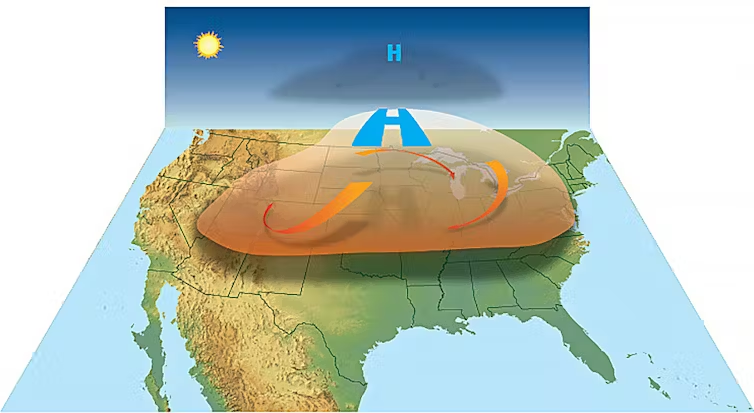
“Heat dome” is a term used by the news media to explain extreme heat conditions across large geographic regions.
The American Meteorological Society maintains a glossary of meteorological terms and added the term “heat dome” and this definition in March 2022: “An exceptionally hot air mass that develops when high pressure aloft prevents warm air below from rising, thus trapping the warm air as if it were in a dome.”

This is not the same as a heat wave, which is a spell of three or more abnormally hot days.
A heat dome develops when a ridge of high pressure builds over an area and resides there for a week or more. High pressure is associated with very few clouds and lots of sunshine, leading to warm temperatures near the surface. The sinking motion in the high pressure prevents warm air near the surface from rising. This motion causes further warming of the air by compression. Unless the upper atmospheric pattern changes, the high pressure will continue to exacerbate the hot conditions. The ground also warms and loses moisture, which can lead to drought conditions and the risk of wildfires. The term “heat dome” may also be used in describing drought events.
Hot and humid conditions can lead to heat-health issues. The heat index indicates how hot it feels. The index is calculated using an equation that is a function of air temperature and the relative humidity. The heat index is sometimes referred to as the “feels-like” temperature.
When our bodies get hot, we cool down by sweating. The sweating does not directly cool our bodies — it is the evaporation of the sweat that cools us down. If the air has a high humidity, then the rate of evaporation is reduced. This hampers the body’s ability to maintain a nearly constant internal body temperature.
Steve Ackerman and Jonathan Martin, professors in the UW-Madison department of atmospheric and oceanic sciences, are guests on WHA radio (970 AM) at 11:45 a.m. the last Monday of each month. Send them your questions at stevea@ ssec.wisc.edu or jemarti1@wisc. edu.

