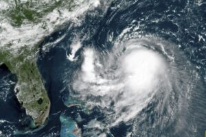
New England dealt with Tropical Storm Henri over the past weekend — nearly the first hurricane to make landfall in New England in 30 years.

As it turns out, that long interval between landfalling hurricanes in that region is unusually long.
It is not terribly uncommon for Atlantic hurricanes to affect the New England states or even the Maritime Provinces of Canada. The reason they are not even more common that far north is because hurricanes are fueled by evaporation of water vapor off the ocean and its subsequent conversion to liquid water (in the form of torrential rains) that releases enormous amounts of so-called latent heat energy to the atmosphere.
This evaporation is greatly enhanced over a very warm sea surface. In fact, sea-surface temperatures of 26 degrees Celsius (about 79 degrees Fahrenheit) are necessary for the formation of nearly all tropical cyclones, some of which mature into hurricanes.
The shelf waters of the Atlantic Ocean, north of Cape Hatteras, North Carolina, are well below that threshold temperature so very few tropical storms continue to strengthen as they surge northward along the Atlantic coast.
The Gulf Stream current, which roars northward along the east coast of North America, usually turns out to sea at about the latitude of the Carolinas. However, the Gulf Stream occasionally has high-amplitude meanders in it (not unlike the waves in our troposphere) that can temporarily force its warm waters much farther north than normal.
Some of the more famous landfalling hurricanes in New England history may well have been associated with such meanders. Luckily, Tropical Storm Henri will most likely serve only as a helpful reminder to a new generation of New Englanders that they are not immune from these destructive storms.
Steve Ackerman and Jonathan Martin, professors in the UW-Madison department of atmospheric and oceanic sciences, are guests on WHA radio (970 AM) at 11:45 a.m. the last Monday of each month. Send them your questions at stevea@ssec.wisc.edu or jemarti1@wisc.edu.

