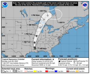
The western Great Lakes region was visited by a rare tropical storm Tuesday when Cristobal made its way into southern Wisconsin.
Rainfall from eastern Iowa to central Wisconsin was intense, with Madison, La Crosse, Wausau and Rhinelander all recording just under 2 inches of rainfall overnight Tuesday into Wednesday. Even more impressive rainfalls were recorded in eastern Iowa, as Dubuque got 2.16 inches, Cedar Rapids got 2.35 inches and Iowa City was hit with 3.47 inches.
Most impressively, the sea-level pressure (SLP) dropped to 989 millibars on Tuesday night — the lowest June SLP ever recorded in Madison. Green Bay’s SLP dropped to 986 — its record for June, breaking one set in 1917. As we have mentioned before in this column, differences in SLP are what drive the wind and so with this record low SLP, it is not surprising that wind gusts in Madison that night reached 30 mph at the airport and were likely higher in other local spots.
Dewpoint temperatures climbed into the low 70s overnight as well — a sure sign of tropical air. In fact, in the Janesville/Beloit area the overnight dewpoints were 75 degrees — more characteristic of Miami or New Orleans.
Though it is not the first time such a tropical system has affected the state, it is a rare event as various sources suggest no more than four other such events have occurred in recorded Wisconsin history.
Ed Hopkins, assistant state climatologist, informed us that the deadly Galveston Hurricane of September 1900 was one of the four. An unnamed hurricane from October 1949, Carla in 1961 and Gilbert in 1988 round out the rest of the storms that had impacted Wisconsin — though in each of these cases it was the southeastern corner of the state that was grazed.

