How’s the hurricane season looking?

Hurricane season runs from June 1 through Nov. 30. The National Oceanic and Atmospheric Administration has been making seasonal forecasts for about the last decade. Their Atlantic Hurricane Season Outlook for this year indicates there is a 70 percent likelihood of having 13 to 20 named storms, of which seven to 11 could become hurricanes, including three to six major hurricanes.

If a tropical storm has wind speeds that are 39 mph or higher, the storm gets a name. It becomes a hurricane if it has winds of 74 mph or higher, and a major hurricane if it has winds of 111 mph or up.

In an average season, the Atlantic Ocean sees 12 named storms, six hurricanes and three major hurricanes. So, if the forecast holds up, we are in for an active hurricane season.

The forecast is based on current and expected conditions. First, an active season would be predicted if the sea surface temperatures are warmer than normal. Warmer temperatures increase evaporation off the sea surface, and that provides the energy for the storm. The forecast is also a function of the El Niño conditions in the Pacific Ocean.

On average, El Niño years are low-hurricane years as during such years a strong jet stream exists over the subtropics. That can destroy the carefully organized circulation of hurricanes.

Perhaps surprisingly, the atmospheric pressure pattern over the Arctic also plays a role in the forecast: High pressure means a weaker jet stream, which favors hurricane development.

Category: Tropical
Tags
Comments Off on How’s the hurricane season looking?

Can we predict the kinds of tornadoes that hit Oklahoma?

Through the end of last week, this spring had been well behind the average in number of reported tornadoes in the United States. Though we are still running a lower than average year, the recent devastation in Moore, Okla., has brought tornadoes back into the news in a dramatic way.

Why we have been below normal so far is a question prompting ongoing research and may be addressed in a future column.

The Moore tornado was rated an EF5, the strongest tornadic storm, with estimated wind speeds in excess of 200 mph near the core. The other alarming characteristic of the Moore tornado was its exceptional size (over 11/2 miles wide) and the fact that it stayed on the ground for so long (over 40 minutes).

Though we understand the general conditions under which tornadoes are likely to develop, the exact details of tornado formation are still not well known. This makes precise prediction of these storms a near impossibility.

In order to protect the public as best it can in the face of this difficulty, the National Weather Service employs a network of trained tornado spotters along with Doppler Radar data to identify tornadoes as soon as they develop.

In fact, since the Barneveld tornado of June 1984, the average warning time for tornadoes has risen from just under 5 minutes to nearly 15 minutes.

Though not a replacement for point-specific forecasts of tornado occurrence, the combination of vigilance in the face of high likelihood and rapid public alert systems has saved many lives in the past 20 years and probably saved dozens, if not hundreds, of lives last week in Moore.

Category: Severe Weather
Tags , , ,
Comments Off on Can we predict the kinds of tornadoes that hit Oklahoma?

What were those lumpy-looking clouds over Madison last Tuesday

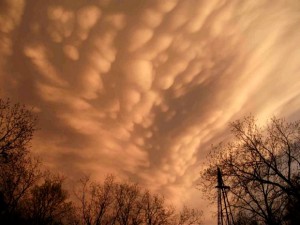
Mammatus Clouds

Mammatus Clouds • Dave Jones, UW-Space Science and Engineering Center

Those types of cloud are called mammatus. They often extend from the bottom of the anvil cloud of a thunderstorm, also called a cumulonimbus cloud, and indicate an intense storm is nearby. This was the case on Tuesday. Mammatus clouds may have a very ominous appearance; however, they are usually seen after the worst weather has passed. When they occur near sunset, they provide a beautiful sky.

Mammatus occur frequently in the Midwest during summer. We do not fully understand why they form, but there are a few hypotheses for their occurrence. Unlike most clouds, which form in rising air, mammatus are associated with sinking air in the upper parts of a thunderstorm. We also know that to form, there must be rapid changes in temperature, moisture and wind between the bottom of the anvil and the cloud-free air below. This rapid change in wind is a hazard to aviation, so pilots avoid mammatus and thunderstorms in general.

The widely accepted cloud classification system used today is based on a scheme introduced by Luke Howard in 1803. This naming convention uses Latin roots to describe the appearance of different cloud types. The Latin ‘mamma’ means udder or breast, and refers to the clouds’ characteristic udder-shaped protuberances.

Rooftop Video

Rooftop Video

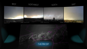
Check out this video to see the storm from the rooftop cameras atop the AOSS Building.

Category: Phenomena

Comments Off on What were those lumpy-looking clouds over Madison last Tuesday

Which is older: rock ’n’roll or computerized weather forecasting?

Rock ’n’ roll is older, although not by much.

On May 6, 1955, a revolution that continues to this day began with little fanfare: the first daily weather forecasts made by a computer were issued. This was the result of nearly a year of collaborative effort between the United States Weather Bureau, the Air Force and the Navy in what was called the Joint Numerical Weather Prediction Unit, or JNWPU.

Formed in July 1954, the JNWPU was charged with applying emerging computer technology to the production of weather forecasts. The numerical forecasts issued during its first couple of years were not nearly as good as the forecasts being prepared manually with just pencil, paper and theory by experienced meteorologists at the Weather Bureau. Many academic meteorologists thought it was folly to pursue numerical weather prediction, and they were not afraid to express their opinions on the matter. But by 1958 the forecasts began to show steady improvement in skill.

Fueled by improved understanding of the atmosphere, better observations (many of which are supplied by satellites that did not exist in any form in 1955), and incredible increases in computer power, the science of numerical weather prediction has developed into an enterprise that now informs or supports a large part of the U.S. economy.

From the seven-day advance warning of Hurricane Sandy to our December blizzard this past year when schools were canceled before a single snowflake fell, we are indeed living in revolutionary times.

We should be proud of the fact that substantial contributions to that revolution have been made at UW-Madison for more than 60 years.

Category: Meteorology
Tags , ,
Comments Off on Which is older: rock ’n’roll or computerized weather forecasting?

Can humans control the weather?

We are not sure we can, but we have always wanted to do so! In the past, people rang bells or fired cannons to prevent lightning or cause rain — producing sound and fury but nothing in the way of success.

The scientific era of weather modification took hold in the 1940s and ’50s with the advent of cloud-seeding experiments. In cloud seeding, airplanes drop particles of dry ice or silver iodide into clouds with temperatures below freezing. These particles are very effective in generating ice particles, with the hope of increasing the amount of rainfall or snowfall.

However, progress in cloud seeding has been slow as the processes are poorly understood. Not only that, these experiments aren’t reproducible in the sense that we can never really know if a seeded cloud would not have precipitated on its own, without assistance.

Farmers have long sought a way to suppress hail. One hailstorm can destroy a year’s crops in a few minutes. Cloud seeding during the early stages of cumulonimbus development is thought to encourage a reduction in hail damage by keeping hailstone sizes small, but again, the results have been mixed.

Another active area of weather modification has been fog dispersal. Fog can shut down an airport for hours, causing delays with negative economic impact. Like clouds, fog can be seeded with materials that cause the water droplets in fog to turn into ice, which then precipitates out, dispersing the fog. While a practice at many airports worldwide, it is impractical to apply over large regions.

Humans have changed the atmosphere in many ways. These changes usually come about as unintended byproducts of modern civilization. So far, humans have been more effective at modifying weather and climate by mistake than by design.

Category: Meteorology
Tags
Comments Off on Can humans control the weather?